Star Lake

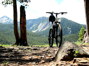
Giant at Star Lake on the Heavenly Valley to Armstrong Pass Trail

After my 2 crashes on the Curly Lake trail in Montana in August I was really looking forward to getting back on the trails. This trail came highly recommended to me, as offering some of the best scenery in the Tahoe Basin. I was told that it was a very strenuous ride, but I was convinced I was up for it… Boy was I wrong, I got slaughtered on this trail!!

Trail map heavenly valley to armstrong

Trail Stats & Information

Nearby City: Minden

Length: 23.43 total miles

Trail Type: Point to Point

Skill Level: [ What the books say ] Aerobically: strenuous. Technical : easy to difficult (mostly moderate)

Skill Level: [ My opinion ] Aerobically: extremely strenuous. Technical : moderate / difficult

Duration: 5 – 7 hours [ my time ] 6.20 hours

Trailhead Elev: 7,500 feet

Top Elev: 9,000 feet

Book Description

This section of the Tahoe Rim Trail passes through some of the most scenic and wild country available to mountain bikers in California—and it’s also one of the least traveled. If you feel left out because you’re not allowed to ride your bike in wilderness areas or national parks, then this is the trail for you. Highlights: Views of Carson Valley, a pristine subalpine lake, a well-built trail, a wonderful wilderness feeling. No motorized vehicles are allowed on this trail.

My Experience

Although I had not been on the bike for a month due to some injuries I acquired on the Curly Lake Trail in Montana, I was pretty stoked and confident that I was up to doing this trail. I was warned that this trail was pretty strenuous, but that doesn’t mean much in most cases.

I was dropped off at 11.00 am the Stagecoach ski lift at Heavenly Valley, I planned to do the ride in about 5 hours, but luckily for me I made a calculation mistake, and told my girlfriend to pick me up at the Armstrong Trailhead at 5.00 pm, which gave me an extra hour… and boy did I need that extra hour!!

The trail starts at the ski lift with a moderate climb, nothing too serious, the first 2 miles were pretty well used by hikers. After the first mile the trail becomes very strenuous and rocky, and it continued to be very rough for the coming 6 miles, and I walked about 80% of this section, and even the walking was strenuous. It took this trail 20 min. to slap me in the face, and made it clear that I was bang out of shape, and this trail was just too strenuous.

Luckily for me, although the first 12 miles is uphill, it is not at all steep, it’s a gradual climb, and the scenery is just stunning.

Completely slaughtered I finally made it to Freel Pass… this is where the fun starts.. downhill all the way to the end!!

The downhill was absolutely superb, narrow rocky singletrack, with superb views. You will really want to open up on this section, but you will soon realize that, that is not a good idea, there is a lot of loose sand / gravel on the trail.
If you do not like narrow rocky singletracks with long drop-offs, then you should avoid this trail. There are also 2 extremely tight switchbacks on this section, hit these too fast, and you will have about 6 seconds to learn to fly, ‘cos it’s a hell of a long drop before hitting the ground.

From Freel Pass to Armstrong Pass is fantastic, but heading down the Armstrong Pass Trail is like a dream come true.. sweeeeet singletrack , smooth and rocky, fast and slow and everything else a mtb’er longs for.

Conclusion

The first 15 miles of this trail is just brutal, I don’t care how fit you are, or how technically gifted you think you are, you will spend a lot of time walking this section. Luckily it is not too steep, and it is very scenic.
The real fun starts at Freel Pass, from here it is 99% downhill or 1.5 hours of some fantastic downhill.

Other Info:

Traffic on Trail : Groups of hikers at Heavenly and at Armstrong Pass

Wild Life : I did not see anything.

Scenery : excellent scenery

Other : Take extra water and energy nibbles.

My Trail Rating : 8.5 / 10

.


.

18 Road in Fruita is home to what some say the best trails in Colorado, and I had heard a lot about Chutes & Ladders and Zippety Doo Daa, and after my fantastic ride in the Kokopelli’s Area, I was really looking forward to this ride. But, was it be as good as the Kokopelli’s?

18 Road Trails Fruita

Trail Stats & Information

Nearby City: Fruita
Length: You decide
Trail Type: Loops
Skill Level: Aerobically: easy – strenuous, Technically: easiest-difficult
Duration: You decide
Season : Year-round; best between October & April
Trailhead Elev: 5,150 feet
Top Elev: 5,500 feet

Guide Book Description

[ Chutes & Ladders ] This trail has some great singletrack riding; one of the better rides in the Book Cliffs area. The fun factor on this ride is very high. The trail traverses along the lower part of the Book Cliffs and follows a wandering line in and out of several dry washes. Do this ride. This trail is located 8 miles north of Fruita.
[ Zippety Doo Daa ] Steep downhills, excellent singletrack, and some very technical sections add up to make this one of the best expert rides in the area. The downhill sections will test the skills of most cyclists.

My Experience

After 20 min. of riding, I started to wonder what all the fuss was about, the ride I was on was flat easy and pretty uneventful, but that soon changed for the better… Lots better!!
The ride I did was : >> Parking Trail Head >> Perimeter >> Chutes & Ladders >> Prime Cut [down] >> Vegetarian >> Chutes & Ladders >> Kessel Run [ one way down only ] >> Western Zip [ Up ] >> Zippety Doo Daa [ one way down only ] >> Parking Trail Head

Conclussion

From the Trailhead the first part of the ride ( Perimeter to Chutes & Ladders ) is pretty flat and uneventful, but halfway up Chutes & Ladders, the ride becomes a hell of a lot better and more technical.. nothing too serious yet, but there were some pretty demanding and fast sections.
Kessel Rim [down] was a hell of a fast and fun section, and definitely worth the run, only minor downside is, that you somehow have to make your way back up to the top section of the trails, because without any doubt, Zippety Doo Daa is the “Piece de Resistence” . Zippety Doo Daa is a just a mental trail, that will have you laughing and shitting yourself at the same time. Do not attempt ZDD if you do not like heights and / or very narrow track with a hell of a penalty for any errors. Certain section of ZDD are easily 75 degree’s downhill, go too slow and you are off, go too fast and you are off!!

one thing is certain, once you are safely at the end of ZDD, all you want is ONE thing, and that is to do it again!!


Other Info:

Traffic on Trail : fairly busy 10+
Wild Life : none
Scenery : Nice scenic trails
Other : There are two parking lots used for these trails, the lower and the upper, I preferred the lower because you can end the ride on a “high” coming down the Zippety Doo Daa , otherwise you will have to cycle back to the top parking lot.

My Trail Rating : 8.5 / 10

.

.

Hyalite to South Cottonwood Trail Bozeman Montana.

The Hyalite to South Cottonwood Trail is a real Jekyll & Hyde Trail, definitely not a trail for the cocky gung-ho riders, and definitely not a trail to test your $89 full suspension Walmart Mongoose.

But, if you are up for a scary challenge then this trail is definitely the dogs bollocks!!

Hyalite to South Cottonwood Trail Bozeman Montana

Trail Stats & Information

Nearby City: Bozeman

Length: 11.4 miles

Trail Type: Point 2 Point, or loop ( for loop add about 14 miles )

Skill Level: Technically very difficult. Physically difficult.

Duration: 3-4 hours

Trailhead Elev: 6,600 feet

Top Elev: 7,920 feet

Book Description

The History Rock trail almost immediately begins a 3 mile climb out of the parking lot. The first 1/2 mile is a good warmup before it becomes steep and sustained for about 2 miles to a junction. This is all cleanable, but will definetly get your heart pumping. Once you reach a meadow with beautiful views of Mt. Blackmore, you know you are done climbing, from here on it is downhill.
Technical switchbacks, rocks and roots will make this a terrifying ride.

My Experience

Traihead was easy to find, it was well marked easy to follow. The first 20 minutes on the History Rock Trail was easy going, and I was pretty confident I would manage to reach the top without stopping.. 10 minutes past History Rock and I was walking!! and I probably spent 10-15 walking, this trail was killin’ me!!.

The strange thing about this trail, is it looks and feels easy, it is not overly steep, the trail is in good shape, not rocky or many roots, but that was just deceiving!!.. I am a fairly decent climber, but you would have to come from a very good stable to make it to the top of this one without stopping and walking.

Once at the top, it all opens up to a mountain meadow with stunning views, and right there in front of you, is a beautiful very narrow singletrack dropping down as far as you can see.. I am not much of a poet, but when I saw that I almost became one!

I was off like a greased whippet screaming down the smooth singletrack, just as I was hitting take off speed, the trail became rocky, and I was up & down like Bangkok Betty still going too fast, then out of nowhere a 130 degree switchback was in front of me. Don’t ask me how I did it, but I managed to get around it in one piece, but I had been warned, this trail is not to be taken lightly. The 5 miles that followed were darn right abusive and pretty scary, absolutely zero room for error, if you fall on this trail, you are gonna have some serious bacon… and that’s if you’re lucky, this is definitely not a trail you want to fall off your steed. Uncomfortable with large rocks and tech switchbacks?.. how about a 3 foot fall on a switchback? thank the lord I saw it on time and managed to come to a safe stop, ‘cos if you Endo here, you are gonna have 5 seconds to learn how to fly, or get hurt very badly..

This is a fantastic trail, but to fully enjoy it you have to remember 2 very important things.. Go too fast and you are gonna get seriously hurt, and go too slow and you will get seriously hurt

Treat this trail with respect and don’t forget to thank the ” Trail Guardian” if you make it down in one piece.

Conclusion

Great Trail with a high buzz factor and some great views, really sweet singletrack. The climb is physically very demanding, and the downhill is pretty abusive and technical

Other Info:

Traffic on Trail : no one untill the last mile from the Cottonwood TH

Wild Life : too tired to notice while climbing, and too much concentration on the downhill to notice

Scenery : Some very scenic stretches

Other : Just be very careful and Good Luck

My Trail Rating : 8.5 / 10

.

.