C’mon, let’s be honest asking someone what the best trails are, is like asking someone what their favorite movie is.. everyone is gonna have their own favorites. But, believe it or not it is by far the most asked question I get… AND it’s the most used search engine term used by people landing on my various sites ” The 10 best mtb trails in the USA” so I decided to put my top 10 together, but it turned out to be VERY difficult, and it quickly became My Top 15 Mountain Biking Trails in the USA..
Before I continue with my list, I have to explain that a few of the trails mentioned in my Top 15 list could also be listed in my Top 15 Worst Trails in the USA.. Let me give you an example.
The first time I did the world famous “Slickrock Trail” in Moab I HATED it, it was a nightmare, I started at about 11am on a weekend and their was HUNDREDS of riders on the trail, to the point where you had to wait your turn on certain sections.. I hated every second of it.
A year later I was prepared, and I started at 6.30am, I had the trail to myself and it was FANTASTIC!, I loved every second of it.
So what I’m trying to say, is that it is not just the trail, but the whole package.. Time is important, weather, how you feel, how the bike performs etc..etc.. When all the above fall into place you have yourself a perfect Trail.
Now, everyone that knows me, knows I’m a Moab Junkie, I love riding the slickrock trails Moab has to offer, and I could easily have 10 Moab Trails in my Top 10. If I had to choose a TOP MTB DESTINATION, it would be without any doubt Moab, however if you put a gun to my head and made me tell you my all time favorite mtb trail, I would kick and cry, but it is probably Cold Creek to Star Lake to Armstrong Pass down Corral Trail in South Lake Tahoe. But next year it might well be another trail.
This is the list of my best 15 Mountain Bike Trails. This is not about trails I have read about, or trails others have told me about, No, I have ridden all these trails numerous times.
The Top 15 Mountain Biking Trails in the USA [alphabetical order]
 Amasa Back Trail – Rockstacker Trail – Moab – Utah
The Amasa Back is a prime example of a trail that could be the best trail you have ever experienced, or if not timed right it can be a nightmare!. This trail gets VERY busy during weekends and holiday’s so AVOID.
If you are able to get an early start on a week day, then you will experience a ride of a lifetime. The Amasa Back Trail is fantastic and scenic, and it is a pretty easy going trail.
Within the first minute you will be welcomed by “Mr Toad” this very short but very daunting section has put a very quick end to a lot of “first timers” make it past Mr Toad, and continue on a fantastic gradual climb on 100% slickrock to the top where you have stunning views of Jackson Hole and the Valley. Once at the top, the faint hearted can return the same way you came up. If you are up for a fantastic but very technical challenge you continue onto the Rockstacker.
The Rockstacker is a very scenic but very technical trail, and should not be taken lightly.
Hopefully you make it back onto the Amasa Back for a mayhem gauntlet all the way down to where you started.
Trail Stats & Information Amasa Back
Nearby Town: Moab
Length: 11.06 miles
Trail Type: Out & Back (lollipop) or loop with Jackson (not recommended)
Skill Level: [what the books say] Technically very difficult to extreme. Physically very difficult.
Skill Level: [My Opinion] Technically moderate to extreme . Physically moderate / demanding
Duration: Book say’s 2-3 hours my time 4.02 hours
Trailhead Elev: 4,000 feet
Top Elev: 4,800 feet
Amasa Back Trail Review
Armstrong Saxon Creek and Mr Toads Wild Ride – South Lake Tahoe – California
This trail will blow you away, it’s fantastic. Again, for the best experience try and get an early start and avoid weekends.
Armstrong is a great ride, both up and down, the climb snakes itself between the huge boulders that are strewn over the length of the trail.
At the Armstrong Pass junction the TRT trail continues to climb, however this section is more strenuous than the previous miles, not so much technically, but because of some very loose sand / gravel on the trail. Both Armstrong and the TRT section is very scenic, and excellent trail conditions. After 3 hours of great climbing, the trail tops out… from this point on, it’s 98% downhill, and not just any old downhill, this section puts all and any theme park to shame.. It’s time for a 9 mile downhill roller coaster ride. The first part of the “gauntlet” is short lived, a grade 5 section forces every human with a will to live, get off their steed and walk this section. Once that’s behind you, there is miles of fantastic but technical and narrow singletrack to enjoy. Just when you are on the brink of thinking you are immortal, Mr Toad brings you back to your senses. Let me just be completely honest, NOTHING I say, or the photo’s and videos you see online will give you a real impression of Mr Toad… It is the craziest shit I have ever seen, let’s put it this way, if I had the best DH bike on the market, with the best body armor on the market, and you offered me a million buck to ride down Mr Toad, i know there is no way I could convince my brain and my body to take me down.
Trail Stats & Information
Nearby City: South Lake Tahoe
Length: 18.84 total miles
Trail Type: Loop
Skill Level: [ What the books say ] Aerobically: strenuous. Technical : difficult
Skill Level: [ My opinion ] Aerobically: strenuous. Technical : difficult / mental
Duration: 4 – 4.5 hours [ my time ] 5.58 hours
Trailhead Elev: 6,200 feet
Top Elev: 9,600 feet
Trail Review Armstrong Saxon Creek and Mr Toads Wild Ride – South Lake Tahoe – California
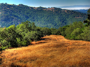
Bangtail Divide Trail – Bozeman – Montana
Oooohhh yes!! this trail is what mountain biking is about, not too strenuous, 23 miles of sweet singletrack through stunning scenery. The trail is well maintained and well marked. The scenery is fantastic, and it came with the smell of fresh pine and 1000′s of wild flowers. The 2-3 hour total climb is rewarded with a fantastic smooth downhill with in most places more than enough visibility to open up to a fair speed.. Don’t open up too much, cos there are a few very tight switchbacks that appear out of nowhere, and some have some pretty brutal drops that you definitely don’t want to hit going too fast.. If this trail doesn’t put a smile on your chops, then nothing will!
All in all, the Bangtail Divide Trail is a definite “Must Ride Trail”.. I did this one in 4 hours 29 min. and I enjoyed every second of both the riding and the scenery.
Trail Stats & Information
Nearby City: Bozeman
Length: 23.8 miles
Trail Type: Point to Point with shuttle or loop [ for loop add 8 miles to total length ]
Skill Level: Aerobically: strenuous; Technically: easy
Duration: 4-6 hours
Trailhead Elev: 5,560 feet
Top Elev: 7,950 feet
Bangtail Divide Trail Review
Cold Creek – Star Lake – Armstrong Pass – Corral Trail – South Lake Tahoe – California
This might well be my favorite Mountain Biking Trail, or should I say that the section from Freel Pass down Armstrong and Corral Trail, this section is the best experience you could possibly imagine.
I’m glad to say that getting to Freel Pass is mental!, I did it twice, once coming up Cold Creek, and once coming up from “Heavenly” and they are both extremly physically demanding.
Once at Freel Pass, you can rest assure that the real fun is about to start. 100% fun filled adrenalin rush that will last between 1.5 – 2 hours… that’s if you manage to stay on your steed. From Freel Pass all the way to the finishing point could well be the best ride in the USA.
For the real “Gear Grinders” among us, at the Armstrong Pass, you can continue on the TRT and head down Saxon Creek and Mr Toads Wild Ride.. Let’s put it this way, once you are at Freel Pass, no matter which way you choose, it’s gonna be a 10/10 ride.
Trail Stats & Information
Nearby City: South Lake Tahoe
Length: 21.01 total miles
Trail Type: Point to Point ( for loop add about 3 miles )
Skill Level: [ What the books say ] Aerobically: strenuous. Technical : difficult
Skill Level: [ My opinion ] Aerobically: strenuous. Technical : moderate
Duration: 4 – 6 hours [ my time ] 7.05 hours
Trailhead Elev: 6,500 feet
Top Elev: 9,500 feet
Trail Review Cold Creek – Star Lake – Armstrong Pass – Corral Trail – South Lake Tahoe – California
Deer Creek Trail – Crested Butte – Colorado
This Trail can be done as a loop, P2P or an Out & Back. I did it as a P2P. I personally would NOT do this as a loop, because you spend more than 12 miles riding on a road, and in my books it takes away from the REAL experience of this trail. This trail is in my favorites list as a P2P or out & back.
Deer Creek Trail offers about 10 miles of fantastic singletrack, but does not attract the HUGE crowds that the “famous” 401 attracts. Get an early start if possible and the world is yours. The singletrack section is superb both the trail and the views. When I did this trail it was freezing and snowing, but I still loved it. This trail has an extreme remote feeling to it and you feel like you are the only person on earth!!
For the real gearheads among us I would suggest doing this as an out & back, giving you 20+ miles of sweet singletrack.
Trail Stats & Information
Nearby City: Crested Butte
Length: 27.1 total miles
Trail Type: Loop
Skill Level: Aerobically: strenuous, with a lot of climbing and descending at high altitude. Technically: easiest-difficult
Duration: 3 to 6 hours
Trailhead Elev: 9000 feet
Top Elev: 10750 feet
Trail Review : Deer Creek Trail – Crested Butte – Colorado
Downieville Classic – Downieville – California
This trail really is Kick Ass.. and YES, it probably has the highest adrenalin pumpin’ fun factor of all the trails I’ve been on ( joint 1st spot with Cold Creek to Star Lake to Armstrong Pass down Corral Trail in South Lake Tahoe )
The flow and speed on this trail is amazing, kudos to the Downieville trail builders for doing such an amazing job.
There are two ways of doing this Trail, the one I did is starting in Sierra City and destroys you with a brutal 8 mile solid climb. The easy way is getting a shuttle to drop you off, so all you have to look forward to is the sweetest 13 miles you might ever experience. Is this trail is scenic ?.. haha.. I would not have a clue, all I know is, it’s rad!
Trail Stats & Information
Nearby Town : Downieville / Sierra City
Length: 21.94 mi
Trail Type: Point to Point
Skill Level: [what the books say] no info
Skill Level: [My Opinion] Technically moderate – challenging. Physically demanding – very demanding if starting in Sierra City.
Duration : My time was 04:31:17
Elev Gain: 3,907 ft
Top Elev : 5,177 ft
Min. Elev : 2,886 ft
Downieville Trail Review
Gold Bar Rim Trail down Portal – Moab – Utah
The Gold Bar Rim Trail down Portal is a trail of a million, and although I have only done this gem once, it is easily on of my favorite trails. If, like me you love remote rides, then this is your playground, remote miles and miles of slickrock goodness. However, because this trail is so remote, you really need to be prepared. The Gold Bar is a long tiring remote trail and for these reasons can be very dangerous. If you don’t like heights, or extreme drop offs, do not attempt this ride. If however you feel comfortable in these situations, this could be your next favorite trail.
[ on a side note, Up Poison Spider and down Gold Bar could possibly be an even better option. Stay posted I will be riding this option]
Trail Stats & Information
Nearby City: Moab
Length: Shuttle 18.5 total miles [ Gold Bar Rim down Portal]
Trail Type: Shuttle Loop or Out & Back
Skill Level: Technically and Physically brutal, relentless, and very dangerous.
Duration: 6-10 hours
Trailhead Elev: 4,575 feet
Top Elev: 5,400 feet
Trail Review : Gold Bar Rim Trail down Portal
Hall Ranch – Lyons – Colorado
I have a very soft spot for Hall Ranch, I started traveling with my mountain bikes 5 years ago, and started posting trail reviews 4 years ago. I had done well over 100 trails throughout the USA before I did this trail for the first time. Hall Racnch went straight to number one!.. It was PERFECT the first time, and it was PERFECT the second time.
Be warned, for a perfect experience, try and get an early start, ‘cos this trail is very popular abd can get VERY busy with both riders and hikers.
Hall Ranch Trail is like no other, and the 10 miles it has to offer is very versatile with a rock section that is both technical and fun, to miles of sweet singletrack.
4 years down the line and 100’s more trails and Hall Ranch is still on the best trails list.
Trail Stats & Information
Nearby City: Lyons
Length: 10 total miles
Trail Type: Loop
Skill Level: Aerobically: moderate. Technically: moderate+
Duration: 1.5 to 2.5 hours
Trailhead Elev: 5500 feet
Top Elev: 6800 feet
Hall Ranch Trail Review
Hartman Rocks – Gunnison – Colorado
Hartman Rocks is not a trail, it’s a trail system, miles and miles of fantastic trails all linking each other. You can easily spend a few days on this trail network, and still not get to ride all the trails. I spent more than 7 hours on these fantastic trails, and it seemed like 2 hours. the combination of great weather, excellent trails, no people and stunning views, made my day a perfect one.
If like me, you love to bike in open rugged spaces with stunning views and fantastic singletracks, then Hartman Rocks is definitely gonna put a smile on your chops.
Trail Stats & Information
Nearby City: Gunnison
Length: +6000 acres of trails
Trail Type: You decide
Skill Level: Physically : easy – strenuous, Technically: easy – moderate
Duration: You decide
Trailhead Elev: 7700 feet
Top Elev: 8300 feet
Trail Review Hartman Rocks
Henry Coe State Park – Gilroy / Morgan Hill – California
This trails system came as a complete surprise to, a lovely surprise. I had never heard about Henry Coe State Park, and stumbled on it by chance. The trails are superb, they are some of the sweetest singletracks you could imagine. No matter how you link these trails, you are going to start in the valley and are going to climb quite a few miles to reach the tops. Luckily even the climbs are fantastic, but nothing compared to the Mayhem fast singletracks that take you back down. There are 100’s of miles of trails to choose from, and as far as I know they are all fantastic. I spent 3 wonderful days on these trails, and I just touched the surface of what Henry Coe has to offer. Fantastic trails and a fantastic Mountain Biking Destination for day long singletrack epics.
Trail Stats & Information
Nearby Town : Gilroy – Morgan Hill
Length: Your call
Trail Type: Loops
Skill Level: [what the books say] no info
Skill Level: [My Opinion] Technically moderate. Physically demanding – mental
Henry Coe Trail Review
Hidden Valley Trail onto Moab Rim Trail – Moab – Utah
I have a very special bond with Hidden Valley, it was the very first Moab trail I ever did, and ever since that ride I have been sold on Moab, Hidden Valley turned me into a Moab Junkie.
Every year for the past 6 years I spend October in Moab, and Hidden Valley is ALWAYS the first trail I ride, and the 4+ weeks I stay in Moab, I ride it at least once a week. I still love every second on this trail. Once you portage your bike for about 40 min. to Hidden Valley, the world is yours, and chances are you will see nobody. Although this trail has an extreme remote feeling to it, you are actually only a few miles from Moab if something did happen. This trail also has the steepest grade ( +22 ) and longest solid downhill section (1 mile) of all the Moab Trails. Your brakes will endure more on this section than an average mtb’er will in a whole year of riding.
Like so many Moab Trails, this one is not for the faint hearted.
Trail Stats & Information
Nearby Town: Moab
Length: about 13 miles (14.3 miles if you visit the view point)
Trail Type: Loop or Out & Back
Skill Level: [what the books say] Technically extremely difficult to downright abusive. Physically difficult
Skill Level: [My Opinion] Technically moderate. Physically moderate
Duration: 2-4 hours
Trailhead Elev: 4000 feet
Top Elev: 5400 feet
Trail Review Hidden Valley
Highline Trail – Sedona – Arizona
Where does one start to try and describe the Highline Trail?
Let me start with some bad news ( good news to some) This absolutely FANTASTIC Trail is NOT marked or mapped, which is great, because it keeps the “Tourists” off. The good news is ( bad news for some) Sedona has a great group of serious mountain bikers that are more than happy to take a fellow mountain biker on this amazing adventure.
Did I say Adventure?.. Yes, the Highline Trail is a Mountain Biking Adventure through some of the most beautiful and rugged scenery. The Highline Trail is 10 miles of slickrock and singletrack delight.
This is without doubt one of the best and most unique trail you might NEVER ride.. I am proud to have been given the chance by the Sedona MTB Chapter to have experienced this beauty.
Trail Stats & Information
Nearby Town : Sedona
Length: 10.64 miles
Trail Type: Lollipop
Skill Level: [what the books say] no info
Skill Level: [My Opinion] Technically difficult. Physically moderate / demanding
Duration : My time was 03:41:00
Elev Gain : 1,822 feet
Top Elev : 4,712 feet
Min. Elev : 3,964 feet
Trail Review Highline Trail
Kokopellis Trails – Fruita – Colorado
The Kokopelli’s Trails are a Mountain Bikers dream, I don’t care what your name is, how much your bike costs, and how tight or baggy your clothes are.. You WILL love these trails. Aany mountain biker who can step forward and say he / she does not like these trails, obviously needs to start looking for a new hobby.
The trails are ALL fantastic, technical but far from impossible, stunning views, uphill climbs, fast downhill bombs, smooth singletracks, bumpy singletracks, and lots more.
The Kokopelli Trails get very busy, so for the best experience plan your rides well. Spend hours and hours on some of the best trails the USA has to offer. From a 2 hour relaxing loop to a 40+ miles of Epic Splendor.
Trail Stats & Information
Nearby City: Fruita
Length: about 41 miles
Trail Type: Loops
Skill Level: Aerobically: easy – strenuous, Technically: easy – very difficult
Duration: 6+ hours
Trailhead Elev: 4500 feet
Top Elev: 5300 feet
Kokopellis Trail Review
Munds Wagon Trail and Schnebly Hill Trail – Sedona – Arizona
Your biggest enemy on this trail is the scenic beauty. Munds Wagon trail is so scenic, it’s difficult to stay focused on the the trail.
Munds Wagon Trail is both technically and physically very demanding, and because of this, it might not be everyones cup ot tea.
The great thing about this trail, is that you have to “earn” the reward, the higher you go, the better it gets.
We all know that NO trail is perfect, but this one, in my opinion comes close, actually, the trail itself is perfect, if there was a way to get rid of all the jeeps on Schnebly Road, and the helicopters that buzz around, then this trail would be “The Perfect Trail”.
Trail Stats & Information
Nearby Town : Sedona
Length: 21.55 miles
Trail Type: Lollipop
Skill Level: [what the books say] no info
Skill Level: [My Opinion] Technically difficult. Physically very demanding
Duration : My time was 05:53:44
Elev Gain : 3,304 feet
Top Elev : 6,504 feet
Min. Elev : 4,135 feet
Munds Wagon Trail and Schnebly Hill Trail Review
Slickrock Trail – Moab – Utah
The Slickrock Trail in Moab, not just any trail, it’s the trail that put Moab on the map as probably the best MTB destination in the world. It’s also the most famous mountain biking trail in the world, and I would say the most unique.
The first time I did the Slickrock was 5 years ago, and I HATED every second of it.. It was a zoo, like disney land on a free day.
Luckily however, I did see the potential of the trail, and was better prepared the second time.
To fully enjoy this fantastic and unique trail, you have to get a very early start on a weekday. If you are able to get the timing right, then you will know why The Slickrock trail is one of the best and most unique trails in the WORLD.
Trail Stats & Information Amasa Back
Nearby Town: Moab
Length: 9.85 miles
Trail Type: Lollipop
Skill Level: [what the books say] Technically very difficult to extremely dangerous. Physically very difficult to abusive
Skill Level: [My Opinion] Technically moderate. Physically demanding
Duration: Book say’s 2-3 hours my time 2.45 hours
Trailhead Elev: 4,575 feet
Top Elev: 4,802 feet
Slickrock Trail Review
There are so many more trails I would love to add, but I have to stop somewhere. I travel full time looking for new mtb trails, if you have a favourite trail, I would love to hear about it, and hopefully ride it one day.
Please leave a comment below and share info about your fav. trail


This Flat Pass Trail review is proudly sponsored by :