Henry W Coe State Park Mountain Biking

Henry Who?? … Yep, that was my first response when I knew I was gonna ride in this area.. Now let’s be honest how many people have heard of the Henry W. Coe State Park in California? 
In the Henry W. Coe State Park brochure they call it ” A Mecca for Mountain Bikers”.. Yeah sure I thought to myself, if I had a dollar for every park that said that, I would be rich.
But anyway, I was here for a few weeks and decided for myself if this really was a “Mecca for Mountain Bikers” or just another false alarm..

Henry W. Coe Trail Map


I spent 3 days on these trails, but because you can link and loop however you wish, I’m just going to write about the area in general in one review rather than 3 separate  trail reviews

For a LARGE Map click here


Trail Stats & Information

Nearby Town : Gilroy – Morgan Hill

Length: Your call

Trail Type: Loops

Skill Level: [what the books say] no info

Skill Level: [My Opinion] Technically moderate. Physically demanding –  mental

DAY 1


DAY 2


Day 3


Book Description

Within the over 81,000 acres of Henry W. Coe State Park are about 100 miles of roads and trails that are open to mountain bikes.  The rugged terrain offers a variety of riding options ranging from moderately difficult to extremely difficult.   There are practically no easy trails for bikes.  One intermediate to advanced mountain biker, after a ride in Coe Park, commented, “The riding was the most physically demanding I have ever done!”


Day 1


Day 2


Day 3


My Experience


Day 1 Trails :

Start at : Coyote Creek TH >> head up Coit Rd >>Pick up Ansa Trail on the right >> then onto Jackson Trail >> at the top veer off onto Elderberry Trail >> then make a right and climb Tower Trail >> after a short ride veer onto [Rock] Spring Trail >> onto Jackson Rd >> to Wasno Rd >> take a right onto Dexter Trail >> head down and take a righ onto Grizzly Gulch and take it all the down to Coyote Creek TH where you started.

Day 2 Trails :

Start at : Coyote Creek TH >> head up Coit Rd  for a short while >> veer right onto Grizzly Gulch for a few minutes >> then take a right onto Spike Jones Trail >>bare left on Steer Ridge Rd. >> then take the Serpentine Trail to the end >> left on Grizzly Gulch >> take a right and climb [walk] Tower Trail >> left on Jackson Rd >> continue down Jackson Trail >> left onto Anza >> onto Coit Rd and back to Coyote Creek TH

Day 3 Trails :

Start at : Coyote Creek TH >> head up Coit Rd  for a short while >>veer onto Grizzly Gulch >>then take a left onto Cullen Trail >> trail becomes Anza Trail stay on it >> then head up the Grapevine Trail >> then onto Cattle Duster >> down the Domino Pond Trail >> take a right on Wasno Rd >> sharp left onto Kelly Lake Trail >> down to Kelly lake and then extreme climb [walk] to Wagon Rd. >> right onto Wasno Rd for a short climb >> downhill on the Tule Pond Trail >> right onto Grizzly Gulch and take it all the down to Coyote Creek TH where you started. 


As I mentioned above, I had never heard of Henry W. Coe State Park, now that doesn’t mean much at all, there are 1000’s of places I have never heard of, but I am pretty updated and well informed about [most] Top Mountain Biking Destinations.
I enjoyed every second I spent on these trails, the trails are 95% sweet singletrack, and I mean singletrack!!
The trails are very well marked, but not overdone, the free maps at “Hunting Hollow TH” are excellent, and it would be pretty difficult to get lost on these trails. ( note that there are NO maps at Coyote Creek TH )
All my rides started at Coyote Creek, that offers free parking ( unlike Hunting Hollow that is $6 )
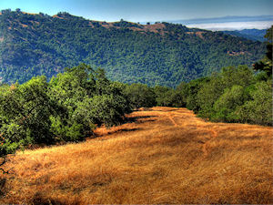
All the trails start by going up, and I don’t care how fit your are, you will spend some time walking with your steed. The views are fantastic, as is the scenery 360 degrees around you.
You would have noticed that some of the trails are roads, but don’t let this fool you, these are not roads, Yes in theory they are “Fire Roads” but even these are a hell of a sweet ride, and better than most trails you find elsewhere.

I enjoyed the climb, even though it was brutal and I spent a lot of time walking, this did not matter, I was already sold by these fantastic network of trails. Once you reach the “Top” you are gonna get blown away by the miles and miles of the sweetest open singletrack you could ever wish for, and the hours you just spent climbing and sweating is all forgotten.

I did these trails in the beginning of September, now I’m not a 100% convinced if this is the best time or not, what I do know, is that it was HOT!!, and I mean hot!. Luckily I like all things hot, but I would love to know when the best time is to ride these trails.. If you are a local, please post a comment and let me know. 

The 3 days I spent on these trails, were fantastic, but I just touched a very small portion of what Henry W. Coe has to offer. I’m glad there is so much more to experience here, ‘cos I will definitely be back to get some more.


Conclusion

YES, I can confirm that Henry W. Coe State Park is a mecca for Mountain Bikers, I will even go as far as to say that it is even in my Top 3 of MTB destinations.
The tails are fantastic, REAL singletrack, the trails are really well marked, the trails are empty, in the 3 days I was on the Trails I saw ONE hiker, and I was even on the trails during Labour Day Weekend. The views and scenery are fantastic, and there are so many fantastic trails here, you can decide on how long a loop you want to ride. 

Your biggest enemy on these trails is the sun and heat, do not under estimate these, I started my rides at the crack of dawn, and by 10 am it was getting pretty unbearable.


Other Info:

Traffic on Trail: EMPTY, 3 days on the trails even during Labor Day Weekend, and I only saw 1 hiker

Wild Life : PLENTY – Bob Cat – Coyote – Wild Boar – Skunk – Deer – Wild Turkey

Scenery : Fantastic views and scernery

Getting There : From Gilroy take Leavesley Rd to New Avenue, then Right onto Roop Road, follow all the way till it becomes Gilroy Hot Springs Road. Pick up map at the Hunting Hollow TH, then continue till the road dead ends at Coyote Creek  TH

Other : It gets HOT here, take extra fluids and nibbles, try and get a very early start. Check yourself for Ticks after the ride, I had a few using me as an “All you can eat”
“Stickers” are a pain here, I actually threw one pair of socks away ‘cos they were covered in them so if possible wear long trousers or a really old pair of socks. 


My Trail Rating : 10 / 10 with a GOLD Star


North Yuba River Trails - Downieville

The North Yuba River Trails Downieville, 16 miles of fantastic singletrack


Due to the very high amount of snow that was dumped on the range during the previous Winter and early Spring, most of the trails I had planned to shred were still snowed in, however the North Yuba River Trail was one of the few trails that were accessible. The North Yuba Trail is a highly rated +15 miles sweet singletrack that follows the Yuba River from Downieville to the Indian Valley Campground.
So, did this trail excite me as much as the Downieville classic?


The North Yuba River Trail Map


Trail Stats & Information

Nearby Town : Downieville

Length: 15.23 mi

Trail Type: Point to Point

Skill Level: [what the books say] no info

Skill Level: [My Opinion] Technically easy – moderate. Physically moderate.

Duration : My time was 03:22:47

Elev Gain: 3,381 ft

Top Elev : 1,155 ft

Min. Elev : 706 ft


Book Description
One of the finest singletracks open to bikes, the newly built North Yuba Trail is a simple trail to follow as there are no other trails intersecting it. This short loop is 16.6 miles round-trip, and the first 8.8 miles of it clings to a north-facing slope above the North Yuba River. The remaining 7.7 miles rides the sometimes narrow shoulder of paved CA 49. But you needn’t ride the highway if you don’t want to. If it’s all single-track riding you want, you can easily make it so by returning in the reverse direction. Whatever the direction, the trail is a fun roller-coaster path, punctuated with some steep but short ascents and descents while weaving through a forest of dogwood, big-leaf maples, and mixed conifers. Adding even more spice to the sweet trail is its narrowness, scattered patches of loose rocks, and some serious drop-offs into the river. Throw in great views of the river with sections of gushing whitewater and you have one heck of a fun ride.


My Experience

As always, I got to the trailhead nice and early, and again without a map, luckily this trails is very easy to follow. To make things easy, I am going to split this trail in two, first section is from Downieville to Goodyears Bar, and the second section is from Goodyears Bar to Indian Valley. I’m doing this, because in my books these two sections offer a different riding experience.
On the first section you get a good 5 minutes to get warmed up, then you start on a long climb, nothing extreme, but it is a 3 mile continuous climb.
The great thing about this, is that once you reach the top ( 3 mile point ) it’s a solid and excellent fast flowing singletrack all the way to Goodyears Bar.
This downhill section really is the highlight of the whole trail, it is fun and very smooth and fast singletrack that really launches you down through the forest. When you reach the road that takes you through Goldyears Bar, you really feel sad the fun came to an abrubt end.
You now follow a very quite road to pick up the second section of this trail, that will take you on another 8 miles of singletrack.
Unlike the first section, where it was a solid climb followed by a solid “bomb”, this section was 8 miles of short up’s and short down’s. There are a few really nice sections on this trail, and the scenery is fantastic, a lot nicer than the first section, however, to me the fun level was lower than the first section.
The North Yuba River Trail is a fantastic 16 mile singletrack, but in an ideal world, I wish I could start with the second section and finish on the fantastic downhill of section one.


Conclusion

The North Yuba River Trail is without doubt a fantastic trail, and is a must if in the Downieville area. To me it did not impress me as much as the Downieville Classic, but that’s a bit like comparing apples to oranges. The trail is sweet singletrack, scenic and both technically and physically moderate.

Another good thing about this trail, is you could easily do this as an “Out & Back”, filling your Hydro at the Indian Valley Campground.
The downside to this trail can be “Crowds”, I had the trail to myself on a Thursday early morning, but Saturday was mental on the trail.. we are talking probably 100’s of people.


Other Info:

Traffic on Trail: Thursday early morning, and the trail was mine!!.. however weekends the trail is mental! Avoid if possible.

Wild Life : none

Scenery : Great scenery

Getting There : Trailhead in Downieville

Other : If you can, try and avoid weekends, trail gets very busy


My Trail Rating : 8 / 10


Yuba Expeditions Downieville

The North Yuba River Trail was proudly sponsored by :

Yuba Expeditions Downieville

Yuba Expeditions is the one stop bike shop in Downieville, For SALES • SERVICE • DEMOS • SHUTTLES • MAPS • SEMI-ORGANIZED ANARCHY and lots more.

Yuba Expeditions is THE place to get all the up to date trail intel, as well as any parts you or your steed will need while in Downieville.

Yuba Expeditions is also the choice shuttle service of Mountain Bike Mayhem, High on Mountain Biking and Mountain Bike Trails USA.


Yuba Expeditions – Downieville Downhill
208 Main Street, Downieville CA 95936
Tel: (530) 289 3010
www.yubaexpeditions.com


10% discount Mention MOUNTAIN BIKE MAYHEM and receive 10% discount on the Shuttle Service.


Downieville Classic

Enjoying the early morning views on the Downieville Classic


For years now I have been hearing lots of fantastic stories about the Downieville Trails. I almost made it here last year, but the South Lake Tahoe Trails kept me occupied longer than planned, so I never made it. As I’m sure you can understand, I was pretty stoked about riding what a lot of people call “The hottest mtb destination in the USA” .. I have been to a lot of fantastic mtb destinations, and was really curious if Downieville would come close to some of my all time favorites, or would it go down as Just OK …


Downieville Classic Trail Map
.

Trail Stats & Information

Nearby Town : Downieville / Sierra City

Length: 21.94 mi

Trail Type: Point to Point

Skill Level: [what the books say] no info

Skill Level: [My Opinion] Technically moderate – challenging. Physically demanding.

Duration : My time was 04:31:17

Elev Gain: 3,907 ft

Top Elev : 5,177 ft

Min. Elev : 2,886 ft

.

Book Description

The trail begins with an 8 mile, 3,000′ climb up the face of the Sierra Buttes, a metamorphic crown that stretches 8,600′ towards the wide-open sky. This legendary climb is known to many as the “Trail of Tears”. It starts with pavement, turns to dirt, and then gradually steepens and narrows to a loose, exposed, shaly doubletrack. We try to make things more comfortable by providing an overhead water mister at the 2 mile point, and Clif Bar supported aid stations at the 4 and 7 mile markers.
After cresting the saddle, the route follows a rolling jeep road to the east rim of Gold Valley and the top of “Baby Heads” – a fast, loose, rocky descent that is responsible for numerous flat tires, get-offs and lead changes. At the bottom of this anarchy awaits Gold Valley and the Pauley Creek crossing. This 30′ wide crossing can be as deep as 3′ during the race, often making it difficult to navigate across at high-speed.
Once across, the route turns to singletrack on the Pauley Creek Trail, a 17 mile creekside plunge that blends flowing turns and rolling jumps with jagged rocks and slippery roots. After descending 2,000′ and crossing three foot-bridges, the trail climbs from the Pauley Creek Canyon to the Lavezzola Creek Canyon, and to the trailhead of the world famous Third Divide Trail. Third Divide is known for it’s Star Wars like speeds, magic carpet tread, bermed corners and lofty airs.
After a thrilling 3 miles, Third Divide Trail dumps out onto Lavezzola Road, which descends to the upper First Divide trail, a 150 year-old water flume built to provide water to a nearby hydraulic mining site. This stretch of trail requires a ton of pedaling as it winds its way downstream through the Lavezzola Creek Canyon, across a saddle, and into the Pauley Creek Canyon to the long awaited streets of downtown Downieville for the finish.


My Experience

I decided for numerous reasons to base myself in Sierra City, just 10 miles from Downieville, and the actual start of the Downieville Classic. As usual I arrived without any maps, and with very limited trail intel. Lucky for me I arrived on a Sunday, and the last day of the Downieville Classic Race, which meant that about 900 mountain bikers had just ridden the trail, thus making it very easy for me to follow… Yeah!.. well that was my plan anyway.
So, very early on a very sunny Tuesday morning I set off with my very basic map, but my excellent plan to follow the well ridden trail.
I knew I had an 8 mile solid climb, but for some reason known to nobody, I kinda forgot how far 8 miles is when it’s all uphill, with zero shelter from the sun. The scary thing about the first 4 miles, is that you can actually see for almost 4 miles the trail you will be taking, and believe me, it’s a longgg climb.
The first 4 miles was a grunt, but at least you can’t go wrong.. this changes when you think you have reached the top, and you suddenly find yourself at a 4 way Trail junction.. that is NOT on the map, and all 4 directions are very well worn.. So, it was decision time, I had come from one direction, so I had a choice of 3 others, Left, Straight Ahead or Right… I decided to go left ( direction Downieville ) luckily for me, the trail dead ended after a mile, so that was an easy decision to return to the junction. My next guess.. Straight Ahead… Not quite lucky this time, the trail ran into a “Wall of Snow” 3 miles DOWN the trail, so I knew this was not the right way either.. So it was the Right Trail I had to take.
From the 4 mile mark, the trail continues to climb for another 4 miles, but nowhere near as bad as the first 4 mile climb. Once you hit the tarmac it’s a mile downhill to the ” Butcher Ranch Trail”…
Now this is the Starting Point to your Reward for the 8 mile climb.. And what a Reward it is..
The next 13 miles is 100% fun pumping fast manic and raw Mayhem!! .. I have not got a clue what was going on around me, all I saw was what was directly in front of me.. going by FAST!!
I was only 10 min. into the 13 miles downhill, and I was already making plans to come back and do this again!
Although this trail offers the max enjoyment level, and it is not extremely difficult, it really should be done with caution, I felt completely at home on this trails, but if you not like very rocky narrow trails with deadly drops, it could be very scary. There are sections on this trail, that will kill you if you fall, we are not talking the 200ft sheer drops that certain Moab Trails offer, but we are talking 30 ft sheer drops into the cold rapids of the Yuba River!..


Conclusion

I have to admit, this trail really is Kick Ass.. and YES, it probably has the highest adrenalin pumpin’ fun factor of all the trails I’ve been on ( joint 1st spot with Cold Creek to Star Lake to Armstrong Pass down Corral Trail in South Lake Tahoe )

The flow and speed on this trail is amazing, kudos to the Downieville trail builders for doing such an amazing job.
There are two ways of doing this Trail, one one I did, with a brutal 8 mile climb, or the easy way, getting a shuttle to drop you off, so all you have to look forward to is the sweetest 13 miles you might ever experience..


Other Info:

Traffic on Trail: I did this ride twice, and both times I had the trail to myself, however if you get caught on the trail between “shuttles” it might be a completely different story..

Wild Life : I would not have a clue.. Way too much fun to notice wildlife

Scenery : Great scenery

Getting There : From Downieville head towards Sierra Cityon the 49. The trail starts on the Sierra Buttes Road

Other : This downhill trail can be extremely fast, however it is shared with hikers and motocrosser’s always be on the lookout for other trail users.


My Trail Rating : 10 / 10 with a GOLD STAR


The Downieville Classic was proudly sponsored by :

Yuba Expeditions Downieville

Yuba Expeditions is the one stop bike shop in Downieville, For SALES • SERVICE • DEMOS • SHUTTLES • MAPS • SEMI-ORGANIZED ANARCHY and lots more.

Yuba Expeditions is THE place to get all the up to date trail intel, as well as any parts you or your steed will need while in Downieville.

Yuba Expeditions is also the choice shuttle service of Mountain Bike Mayhem, High on Mountain Biking and Mountain Bike Trails USA.


Yuba Expeditions – Downieville Downhill
208 Main Street, Downieville CA 95936
Tel: (530) 289 3010
www.yubaexpeditions.com


10% discount


Mention MOUNTAIN BIKE MAYHEM and receive 10% discount on the Shuttle Service.


.

.

.