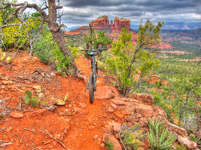

Munds Wagon Trail offers some of the finest views you will ever get to experience on an mtb trail.
The Munds Wagon Trail became one of my all time favorite trails last year, and I was really looking forward to riding this gem again.
Last year I went UP Munds, and continued UP Schnebly, while climbing Schnebly I was already planning coming down this section, next time I was in Sedona.. Well, I was back, and I was planning on sticking to my plan I made a year previous.
However, this time the ride nearly went pear shaped because of a tiny piece of rubber.
Trail Stats & Information

Nearby Town : Sedona
Length: 11.24 miles
Trail Type: Lollipop
Skill Level: [what the books say] no info
Skill Level: [My Opinion] Technically difficult. Physically very demanding
Duration : My time was 04:01:40
Elev Gain : 2,163 feet
Top Elev : 6,219 feet
Min. Elev : 4,437 feet
Book Description
I could not find any Mtb Trail books describing the Munds Wagon Trail and Schnebly Hill Trail, so the below descriptions are based on my personal experience :
>> Munds Wagon Trail : 4 miles ( one way) of sweet scenic and fairly technical singletrack through stunning scenery. The trail is in excellent condition and easy to follow. The rewards are among the best, but you will have to work hard to earn them.
>> Schnebly Hill Trail : At the top of Munds Wagon Trail you will probably think the views cannot get any better.. well think again, the climb continues, and so do the stunning views. The first mile is an excellent narrow “chicken head” singletrack that takes you to the very top of the rim.. Now you are at the Top of the World!!..
Although the trail does continue to “Jacks Can Trail” .. My route took me onto a ( very nice) 4 wheel drive trail and back to Schnebly Hill Road, that then picks up the “Munds Wagon Trail ” for a “Gauntlet” ride back to the Trailhead.


.
My Experience
I was at the Munds Wagon Trailhead at about 8.am, and there was already a handful of cars parked there. I knew this didn’t really didn’t mean much, ‘cos there are a handful of trails that start here. As it turned out, this was the least of my worries.
After getting my steed and myself ready for the ride, my Camelbak mouth piece sprung a leak, and there was no way I could leave with a leaking mouth piece, and of all the spare parts I carry, I did not have a spare mouth piece on me. I have numerous spare Camelbak’s, but they were in Cottonwood, 35 min away.
I decided to call it a day, and head back to Cottonwood. Luckily I decided to take a chance, and drive by the bike shop, in the hope they would be open… Luckily for me they were, and I got a new mouth piece, and headed back to the trail.
Again it was a fantastic and scenic ride, easily one of the most scenic trails.
Conclusion
Munds Wagon Trail and Schnebly Hill Trail is without doubt one of the best and scenic trails in the USA.
Other Info:
Traffic on Trail : A handful of hikers on the first mile of the trail
Wild Life : Too much scenery to notice any wildlife
Scenery : The Best!!
Getting There : West Trailhead From the junction of Routes 89A and 179, take 179 south 0.3 miles. Turn left on Schnebly Hill Road just across the Oak Creek Bridge and go .08 miles to the Huckaby/Margs Draw Trails parking area on the left.
Other : Carry extra fluids, suncream and lipbalm.
My Trail Rating : 10 / 10 with a GOLD STAR
History of Munds Wagon Trail
In the late 1800s, rancher Jim Munds ushered his cattle to the lush mountain meadows on the Mogollon Rim along this very same Bear Wallow Canyon route. In 1896, Munds launched a construction project that by 1902 had transformed the rough, steep trail into a wagon road that made it much easier for Verde Valley homesteaders to bring produce and livestock to market in Flagstaff.When the road up Oak Creek Canyon opened in 1914, Munds Wagon Rd. was displaced as the primary route from Sedona to Flagstaff. With the construction of the current Schnebly Hill Rd. in the 1930s, the older Munds Wagon Rd. was neglected and fell into disrepair. In recent years, the National Civilian Community Corps and U.S. Forest Service restored the trail, now recognized as historic by the state.With no cattle to mind, those who hoof it today can focus on amazing views of Mitten Ridge and the Munds Mountain wilderness. The roughly four-mile (one-way) trek takes you past the “Cowpies” and Merry-Go-Round Rock before connecting with Schnebly Hill Trail. Look also for original retaining walls built by the pioneers; many are still standing.