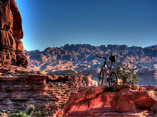


Early Morning on one of the worlds greatest trails, the Porcupine Rim Trail in Moab
The Porcupine Rim Trail in Moab is together with the Slickrock Trail the most popular Moab ride. This trail is probably on the wishlist of more mountain bikers than any other trail, and not just in the USA, but worldwide.
The Porcupine Rim is a fantastic trail, physically it’s an easy ride, 90% being a very fast downhill, however technically this trail can rip you and your steed to pieces.
Many a Mountain Biker has lost the battle on the Porcupine..


Trail Stats & Information
Nearby Town: Moab
Length: I clocked 14,74 miles
Trail Type: P2P [ Point 2 Point ]
Skill Level: [what the books say] Technically very difficult to abusive. Physically difficult.
Skill Level: [My Opinion] Technically moderate to very challenging. Physically moderate
Duration: 2-5 hours
Trailhead Elev: 6,000 feet
Top Elev: 6,800 feet
Book Description
Porcupine Rim is arguably the most diverse of all local Moab rides and definitely one of the most memorable. Aerobically it is moderately difficult, with an 800-foot elevation gain right off the bat. Technically, it’s extremely challenging. An extended climb to the head of Negro Bill Canyon (named for mulatto William Granstaff, a prospector-settler who came to the area in 1877) on a narrow mining track is followed by an unforgettable stretch of double-track leading along the edge of Porcupine Rim, with stomach-churning views straight down on Castle Valley. From a jungle of juniper-piñon, sandstone outcrops, and cacti, you’ll begin a long descent down rugged double-track teeming with drop-offs that often come at you when you least expect it. This leads to single-track, sometimes smooth and other times boulder-strewn. The trail deposits you onto UT 128, and the final six miles back to town are paved. General location: 10 miles east of Moab.


.
My Experience
There is a very good reason why The Porcupine Trail is on the wishlist of so many Mountain Bikers, it’s one hell of a ride, and deserves a spot as one of the Best trails to ride.
I was dropped of at the Trailhead at the break of dawn, the sun had not yet shown herself. This trail can get very busy, and I wanted her all to myself. At 7 am I started my ride.
The first 45 minutes is a climb, nothing serious, and actually even the climb is fun trying to tackle the obstacles.
You know when you are “Topped Out” when you get the fantastic view of Castle Valley. Enjoy the views from here, and take this opportunity to prepare yourself and your steed for the adrenalin pumpin’ mayhem ride that will either put a smile on your chops for a few days, OR have you cryin’ for your “mummy” like a little baby!
The Porcupine has no mercy at all with mountain bikers, go too fast.. you’re fucked, go too slow..you’re fucked, choose the wrong line.. you’re fucked, hesitate .. you’re fucked… So basically if you don’t find the right balance on the Porcupine, either you, your steed, or both are fucked.
Physically this trail is pretty easy, nothing too serious, however technically this trail CAN be severe. The very time I did the Porc. I ended up walking out with my tail between my legs, after destroying TWO derailleur hangers, and shreddin’ my back tire.
The dragons teeth on this trail are brutal, and appear out of nowhere, just when you think it’s safe to open up, a carpet of dragons teeth appear out of nowhere!. Just make sure you have max. puff in your rubbers, otherwise you to, will be walking out.
From the view point to the singletrack section is very technical, not technical because of drops or other dangerous obstacles, but more because of speed issues, clipping, and very sharp and loose terrain that will cause you to wipeout at the blink of an eye, and doing a face plant on the Porcupine is gonna hurt big time!
The fun continues on the singletrack section, this section is VERY technical as well, but different technical to the previous 8 miles. The singletrack has some VERY gnarly stretches that will very quickly put an end to your ride, and a lot more if you are out of luck.
The singletrack is very narrow, and clipping your pedals is inevitable. The speed that can be reached on this section is scary, so you have to make sure your steed is is optimal working order, doing 35 mile on a trail that is less than a foot wide and having a 7 foot gap appear out of nowhere is scary, just hope your brakes are working…
” Well going 35 miles on a trail that is less than a foot wide with a sheer drop on one side is just crazy shit!!. Use your common sense.. “
Yeah, right, that’s what I would think as well, but once you are on the Porcupine, all common sense goes disappears like a fart in the wind, and just like that fart, you just gotta go with the flow on the Porcupine.
Conclusion
Dude, I was on fire, and my loyal steed was smokin’!!, This is the FIRST time I have cleared the Porc. without any need of Trail side maintenance, and / or body bacon.
This time it was a Perfect Storm, the weather was great, I had the trail to myself, I was in top form and my steed was running like a greased whippet.. things just could not have been better.
The Porcupine Rim Trail is unique, and it’s not hard to see why this is one of the greatest trails in the USA and even the World.
Other Info:
Traffic on Trail : I started at 7 am and finished at 11am and saw NOBODY!!
Wild Life : none
Scenery : Absolutely Fantastic Moab Scenery
Other : The Porcupine is a very technical trail, but don’t be put off by this, unlike many technical trails, the Porcupine is 95% doable. It’s VERY hard on your bike, take ALL the parts you have, incl. extra inner tubes, tire, chain and derailleur hanger(s)
My Trail Rating : 10 / 10 with a GOLD Star
Porcupine Rim Trail review is proudly sponsored by :
Moab Rim Campark
At Moab Rim Campark mountain bikers will definitely feel at home among other mountain bikers at this Mountain Biker Friendly Camp groud.
Bike wash, grassy shaded tent sites with stunning views, Full hook ups, semi hook ups, cabins, group shelters, sheltered areas to tinker on the bikes, and lots more.The Porcupine Rim Trail is just 20 min. drive from your campsite.
Moab Rim Campsite has been recommended by “Mountain Bike Mayhem” 5 years running.Mountain Bikers get 10% discount, just bring your bike(s) and mention MOUNTAIN BIKE MAYHEM
For more info vist : Moab Rim Campark
Trail Videos taken on the Porcupine Rim Trail. Oct. 2011

Henry Who?? … Yep, that was my first response when I knew I was gonna ride in this area.. Now let’s be honest how many people have heard of the Henry W. Coe State Park in California?
In the Henry W. Coe State Park brochure they call it ” A Mecca for Mountain Bikers”.. Yeah sure I thought to myself, if I had a dollar for every park that said that, I would be rich.
But anyway, I was here for a few weeks and decided for myself if this really was a “Mecca for Mountain Bikers” or just another false alarm..

I spent 3 days on these trails, but because you can link and loop however you wish, I’m just going to write about the area in general in one review rather than 3 separate trail reviews
For a LARGE Map click here
Trail Stats & Information
Nearby Town : Gilroy – Morgan Hill
Length: Your call
Trail Type: Loops
Skill Level: [what the books say] no info
Skill Level: [My Opinion] Technically moderate. Physically demanding – mental
DAY 1
DAY 2
Day 3
Book Description
Within the over 81,000 acres of Henry W. Coe State Park are about 100 miles of roads and trails that are open to mountain bikes. The rugged terrain offers a variety of riding options ranging from moderately difficult to extremely difficult. There are practically no easy trails for bikes. One intermediate to advanced mountain biker, after a ride in Coe Park, commented, “The riding was the most physically demanding I have ever done!”
Day 1


Day 2


Day 3


My Experience
Day 1 Trails :
Start at : Coyote Creek TH >> head up Coit Rd >>Pick up Ansa Trail on the right >> then onto Jackson Trail >> at the top veer off onto Elderberry Trail >> then make a right and climb Tower Trail >> after a short ride veer onto [Rock] Spring Trail >> onto Jackson Rd >> to Wasno Rd >> take a right onto Dexter Trail >> head down and take a righ onto Grizzly Gulch and take it all the down to Coyote Creek TH where you started.
Day 2 Trails :
Start at : Coyote Creek TH >> head up Coit Rd for a short while >> veer right onto Grizzly Gulch for a few minutes >> then take a right onto Spike Jones Trail >>bare left on Steer Ridge Rd. >> then take the Serpentine Trail to the end >> left on Grizzly Gulch >> take a right and climb [walk] Tower Trail >> left on Jackson Rd >> continue down Jackson Trail >> left onto Anza >> onto Coit Rd and back to Coyote Creek TH
Day 3 Trails :
Start at : Coyote Creek TH >> head up Coit Rd for a short while >>veer onto Grizzly Gulch >>then take a left onto Cullen Trail >> trail becomes Anza Trail stay on it >> then head up the Grapevine Trail >> then onto Cattle Duster >> down the Domino Pond Trail >> take a right on Wasno Rd >> sharp left onto Kelly Lake Trail >> down to Kelly lake and then extreme climb [walk] to Wagon Rd. >> right onto Wasno Rd for a short climb >> downhill on the Tule Pond Trail >> right onto Grizzly Gulch and take it all the down to Coyote Creek TH where you started.
As I mentioned above, I had never heard of Henry W. Coe State Park, now that doesn’t mean much at all, there are 1000’s of places I have never heard of, but I am pretty updated and well informed about [most] Top Mountain Biking Destinations.
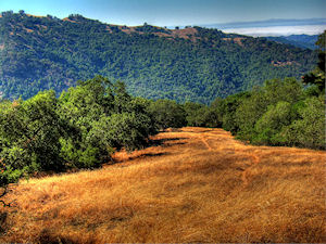
I enjoyed every second I spent on these trails, the trails are 95% sweet singletrack, and I mean singletrack!!
The trails are very well marked, but not overdone, the free maps at “Hunting Hollow TH” are excellent, and it would be pretty difficult to get lost on these trails. ( note that there are NO maps at Coyote Creek TH )
All my rides started at Coyote Creek, that offers free parking ( unlike Hunting Hollow that is $6 )
All the trails start by going up, and I don’t care how fit your are, you will spend some time walking with your steed. The views are fantastic, as is the scenery 360 degrees around you.
You would have noticed that some of the trails are roads, but don’t let this fool you, these are not roads, Yes in theory they are “Fire Roads” but even these are a hell of a sweet ride, and better than most trails you find elsewhere.
I enjoyed the climb, even though it was brutal and I spent a lot of time walking, this did not matter, I was already sold by these fantastic network of trails. Once you reach the “Top” you are gonna get blown away by the miles and miles of the sweetest open singletrack you could ever wish for, and the hours you just spent climbing and sweating is all forgotten.
I did these trails in the beginning of September, now I’m not a 100% convinced if this is the best time or not, what I do know, is that it was HOT!!, and I mean hot!. Luckily I like all things hot, but I would love to know when the best time is to ride these trails.. If you are a local, please post a comment and let me know.
The 3 days I spent on these trails, were fantastic, but I just touched a very small portion of what Henry W. Coe has to offer. I’m glad there is so much more to experience here, ‘cos I will definitely be back to get some more.
Conclusion
YES, I can confirm that Henry W. Coe State Park is a mecca for Mountain Bikers, I will even go as far as to say that it is even in my Top 3 of MTB destinations.
The tails are fantastic, REAL singletrack, the trails are really well marked, the trails are empty, in the 3 days I was on the Trails I saw ONE hiker, and I was even on the trails during Labour Day Weekend. The views and scenery are fantastic, and there are so many fantastic trails here, you can decide on how long a loop you want to ride.
Your biggest enemy on these trails is the sun and heat, do not under estimate these, I started my rides at the crack of dawn, and by 10 am it was getting pretty unbearable.
Traffic on Trail: EMPTY, 3 days on the trails even during Labor Day Weekend, and I only saw 1 hiker
Wild Life : PLENTY – Bob Cat – Coyote – Wild Boar – Skunk – Deer – Wild Turkey
Scenery : Fantastic views and scernery
Getting There : From Gilroy take Leavesley Rd to New Avenue, then Right onto Roop Road, follow all the way till it becomes Gilroy Hot Springs Road. Pick up map at the Hunting Hollow TH, then continue till the road dead ends at Coyote Creek TH
