Case Mountain Trails - Three Rivers - California
These trails came as a complete and pleasant surprise to me, I had never heard of these trails, and was here to visit the Sequoias on my way to Downieville. The Case Mountain Trails are about 3 miles from Three Rivers.
These trails were described to me as ” Like the Downieville Trails were before they became popular” .. Well in that case I was at the right place..
Trail Stats & Information
Nearby Town : Three Rivers
Length: 12.07 miles
Trail Type: Loop
Skill Level: [what the books say] no info
Skill Level: [My Opinion] Technically moderate. Physically moderate.
Duration : My time was 03:57:57
Elev Gain : 2.975 feet
Top Elev : 2,788 feet
Min. Elev : 979 feet
Book Description
I could not find any Mtb Trail books describing the Case Mountain Trails, so the below descriptions are based on my personal experience :
>> The Case Mountain Trails are riddled with fantastic singletracks. The area is not huge, but you can easily spend a day connecting these trails. One thing, these trails are NOT marked, and there are no maps available. I was very lucky to find a local ( Kevin from Three Rivers Hideaway) that was willing to get up at 6 am and show me the layout, and explain the possibilities. The trails here are sweeeet, but hard to know which ones to take.


My Experience
As I mentioned above, this whole area came as a pleasant surprise, I had not done any research at all, and had no plans to ride. While at the Three Rivers Hideaway Campground I noticed two nice looking Steeds, I asked at the office who they belonged to, and the rest is history. Kevin the owner of the steeds suggested we get an early ride in before it got too hot, the next day at 6 am we were on our way. Once on the trails we spent the first 20 min. on a sweet singletrack on one of the very few named Trails, this one was “Old Number One” the climb was gradual and easy, and it took us back onto a Fire Road. I could see 10’s of singletracks veering off in every direction, Kevin spent a great deal of time explaining each trail, cos a couple of days later I would be on my own.
We followed the fire road for about a good 30 min. all uphill, but nothing too serious. While climbing you will notice the very fast flowing singletracks to each side of the road .. These are trails that will be taking you back down.. FAST!!
We finally made it to the point where we had to prepare ourselves for the mayhem ride back down, all and only on sweet singletrack.
The descent was fast and fun, and I did not do too bad with keeping up with Kevin. I do confess that I did quite a spectacular Endo, luckily no serious damage done.
The downhill is really fast, and narrow, and there is zero room for any hesitation. All in all FANTASTIC!
2 days later I went back on my own and did the Trail that came highly recommended by Kevin, same kind of trail I did above, just higher and about 6 miles longer.. Again, it was fast and furious and a good 6 miles of sweet singletrack.
I wish I had more time to explore these trails, I will definitely be back one of these days to try the so many trails I did not manage to ride.
Conclusion
These trails really are sweet, and you are almost guaranteed the trails to yourself. They are however surprisingly well maintained by the local Mtb’ers ( Kudos to them for doing such a great job) Also, what is pretty nice, is that you can reach the High Spots by following the fire road, but 100% of the downhill is miles singletrack.
The downside is, the trails are not marked or mapped, making it very difficult for outsiders to know what the best routes are.. , but maybe this is a good thing!. I was lucky I had a guide that explained the layout to me.
Bottom line is, if you are ever near Three Rivers, you would be mad not to hit the Case Mountain Trails
Other Info:
Traffic on Trail : I had all the trails to myself, I did not see anyone.
Wild Life : King Snake and a Rattlesnake ( huge)
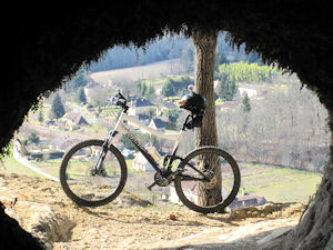
Scenery : Great scenery
Getting There : From Three Rivers continue about 4 miles along the 198 towards Hammond. Just past Three Rivers Hideaway (on the left) take a right at the church up Skyline Dr. Follow Skyline all the way to the Trailhead ( do not veer off of Skyline)
Wild Life : King Snake and a Rattlesnake ( huge)
Scenery : Great scenery
Getting There : From Three Rivers continue about 4 miles along the 198 towards Hammond. Just past Three Rivers Hideaway (on the left) take a right at the church up Skyline Dr. Follow Skyline all the way to the Trailhead ( do not veer off of Skyline)
Other : Take sun lotion and extra fluids, in the summer it can get hot ( 104 when I was there )
My Trail Rating : 8.5 / 10
.
.
.
.