Tag Archive for: mountain biking trails


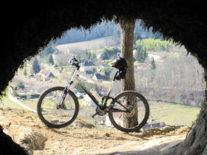
For years now I’ve been hearing and reading some good stories about the Tucson Trails, and although I had tried a couple of times to fit Tucson into my list of destinations, it never panned out.. until this time.

While on one of the Moab Trails in October, I got talking with two fellow Mountain Bikers [ Doug & Bill ] They were a wealth of information about Mountain Biking Trails throughout the USA, which also included the Tucson Trails.

As luck has it, when I arrived in Tucson I unknowingly set up base at the “Desert Trails RV Park” just 3 sites down from Doug who I had met in Moab, and both he an Bill were staying there, this meant I was gonna get the full trail intel incl. free guides.

I spent 4 weeks on the Tucson trails. and I just touched the surface of what Tuscon has to offer. I will definitely be back soon to ride all the trails I missed this time round..


My Experience


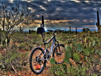
Riding the Tucson Trails for the first time was a great experience, it’s pretty daunting looking up at 40+ ft. cacti, thinking just ONE thing.. “Shit I hope I won’t be huggin’ one of them” .. The brain however must switch off, ‘cos minutes later I was dodging the cacti like I had a death wish.

I was lucky in Tucson, I had 2 well seasoned guides [ Doug & Bill ] that kindly showed me a handful of trails,’cos although the trails great, and clear, they are not very well marked and believe me there are plenty of places one can go wrong, and the Tucson dessert is not a friendly place to get lost. Your safest bet is to, just like me [ if just like me you are lucky ] make use of a guide, followed by a really good map, a shit load of navigation skills, and spare tubes!!. I used more tubes in the 4 weeks in Tucson, than in all the 5 previous years!. I used a “Tuffy” liner front and back, and slime tubes, and still had to take out a mortgage to finance my tubes.. and don’t think if you shred on “Tubeless” you are off the hook, ‘cos you ain’t!
I must say however, that the “Tuffy’ liners really did improve things, and I would highly recommend them in Tucson.

Although there were no really high trails, or at least not the ones I did, this doesn’t mean there are no strenuous climbs, and manic downhill sections, ‘cos there are lots of them, what I call short, brutal & fun.

One of my favorite trails was the pretty technical and very demanding “Brown Mountain” Trail.. don’t be fooled just because it’s just under 5 miles, ‘cos at some point you will curse this trail. I attempted Brown Mountain 5 times, the first 2 times I cleared without any problems apart from destroying my lungs!. However the last three times I ended up walking down, completely defeated or should I say deflated, cos three blowouts in three attempts, because of this Brown Mountain became together with the Porcupine Trail in Moab my most expensive rides, and it kicked my arse!
The final downhill section is pretty sick, and it was actually the first time I opted for semi-full body protection, and boy am i glad I did. The trail consists of of razor sharp rocks, and a lot of very scary looking cacti. This is definitely not a trail where you wanna lose your cool.

Another trail I really enjoyed was the Explorer Trail, another short but brutal trail. This is an “out & back” with a lot of climbing, a pretty technical section and of course a lot of downhill. This downhill is not as steep as the Brown Mountain section, however is is much longer, and because it is not as steep, you are more inclined to open up, and that can be very dangerous. Stay on your steed on this trail, and you will enjoy every minute of it.

The Robles Trail system offers miles and miles of fantastic trails, and it doesn’t matter how you do them, clockwise or counter clockwise, they are great both directions. Some moderate climbs, a handful of technical spots and some really fast flowing runs make the Robles System a MUST!

Another must do fantastic out and back is the Pistol Hill to Three Bridges Trail. This section is about 17 miles of the 800 mile Arizona Trail. There is quite a bit of moderate climbing on this trail, and eventually it physically catches up with you.. I was doing fine until about mile 12, and then my legs and lungs started giving up, and the last climb was very demanding. The really nice thing about this trail, is that it has one of the best finishes you can imagine.. The last 1.5 miles is a manic “Run Rabbit Run” a perfect finish to an excellent trail.

Conclusion

Tucson is a fantastic MTB Destination, although it is definitely not a summer destination, it could just be the best winter destination the USA has to offer. I can only speak for December and January, but the weather and trail conditions were perfect. I was pleasantly surprised at how quite the trails actually were, even during the weekend.

As I mentioned, I was in Tucson for a whole month, and I still just touched the surface of the Tucson trails. I will definitely head back to Tucson next winter, and will definitely explore all the trails I did not get to ride.

Any serious Mountain Biker looking to do some serious Mountain Biking in the winter months should definitely put Tucson on top of the list.


My Tucson Trails Rating : 8 / 10


Doug & BillI would like to thank Doug & Bill for the the time to show me some fantastic trails Tuscon has to offer. Without their guidance and trail intel I would have probably spent more time researching and less time shreddin’.

I’m sure our paths will meet again on a trail somewhere… Kudo’s to you both.


Flat Pass Trail Moab

Flat Pass Trail Moab, also known as Steel Bender

.
If there is one thing there is not a shortage of in Moab, it is Mountain Biking Trails. Everyone has a favorite trail here in Moab, but usually you only hear about  Slickrock,  Porcupine, Sovereign etc. However, the Flat Pass Trail, also known as the Steel Bender, has quite a following of mountain bikers that put this trail on the top of their “Favorites” list.
.
Flat Pass Trail Map

Trail Stats & Information

Nearby Town: Moab
Length: Guide book states 15.5 total miles, I myself clocked 19.4 miles
Trail Type: Loop
Skill Level: [what the books say] Technically difficult to extreme. Physically moderate to difficult.
Skill Level: [My Opinion] Technically moderate. Physically moderate
Duration: Book say’s 2-4 hours [ ?? 2 hours!! ] my time 4.07 hours
Trailhead Elev: 5,200 feet
Top Elev: 6,000 feet

.

Book Description

The ride is highlighted by vandalized petroglyphs, rolling hills with sever transitions at the bottom, and some very beautiful views of the Moab Valley. There are a couple of spots on the trail that can sneak up on you, so keep your eyes on the trail and give blind turns and dips a lot of respect. I you enjoy technical challenge, deep stream crossings, transitions, vertical ridges, gaps and pits, knee-high ledges, rollies, plateaus, babyheads, death-grip-jackhammer stuff into deep sand, weird sliced-bread bedrock, and a ride that can be done form Moab, the Flat Pass is the trail. Trail Surface: Bedrock, loose rock, sand and babyheads on a technical 4WD track, with substantial creek crossings.


.

My Experience

I had heard a lot of good things about the Flat Pass Trail, and it has been on my to do list for a few years, the only reason I kept postponing this ride was because of the high amount of “Road Miles” needed to loop this trail.
The trailhead is easy to find, just head for Kens Lake. The trails starts with a easy climb on a gravel road to the Flat Pass. At this point you head down, and have to make a sharp left and cross the creek, or just do as I did, and miss the turn-off and carry on up a dead end trail untill you realize it ain’t going anywhere, so you will have to turn around and back track.

Once on the real trail, which is mostly slickrock, the real enjoyment begins. The trail climbs moderately with plenty of obstacles to keep you busy, and it’s actual a fun climb. The fun continues until you top out, then you get some really fun sections of hard packed sand.. open up here and ride like a bat out of hell, until you hit the rocky downhill section. Technically quite challenging, but nothing too serious, it’s just a fun bumpy downhill, choose your path, and stick to it. There are a few high drop-offs, but I always managed to find a safe way down..

All in all the trail section of the Flat Pass Trail is fantastic, with a high fun factor, and offers stunning Moab scenery. This trail does not attract the crowds like numerous other Moab Trails does.

Conclusion

The Flat Pass Trail is definitely a “must do” ride if you are in Moab, and I will definitely be doing this one again in the near future. However, I will approach this trail in a different way. Other options for this trail is to ride it as an “Out & Back”  which is about the same mileage as  a loop. Another loop option is to park your vehicle at the end of the trail, and do the road section first, get it behind you, and end the trail on a high. Or if you are lucky enough to be able to get a shuttle, and ride it as a P2P [ point 2 point ]

One bit of important advice for this trail is if you have never done it before, make sure you take a “proper” trail map, ‘cos there are numerous very confusing spots on this trail where the sign posts are missing  and with numerous trails branching off .

Other Info:

Traffic on Trail : none, I had the trail to myself.
Wild Life : A Rattlesnake [ I almost sat on it ]
Scenery : Absolutely Fantastic Moab  Scenery
Other : Carry a proper map, and like all Moab trails a good puncture outfit and extra inner-tubes [ Moab trails are notorious for causing punctures]

My Trail Rating : 8.5 / 10 [ As a P2P I would give this trail a 10/10 ]

.

Moab Rim CamparkThe Flat Pass trail review is proudly sponsored by :

Moab Rim Campark

At Moab Rim Campark mountain bikers will definitely feel at home among other mountain bikers at this Mountain Biker Friendly Campgroud.
Bike wash, grassy shaded tent sites with stunning views, Full hook ups, semi hook ups, cabins, group shelters, sheltered areas to tinker on the bikes,  and lots more.

Flat Pass Trail can be done directly from your campsite as a loop, there is no need for a shuttle.
Moab Rim Campsite has been recommended by “Mountain Bike Mayhem” 4 years running.

Mountain Bikers get 10% discount, just bring your bike(s) and mention MOUNTAIN BIKE MAYHEM

For more info vist : Moab Rim Campark

.


.

.

.

Mountain biking in the Dordogne

The Vezere Valley in the Dordogne, a region in South West France is the undisputed Prehistoric Capital of the World, and the place our Prehistoric Ancestors called home more than 460000 years ago.

Mountain biking in the Dordogne offers a unique experience, offering mountain bikers miles of trails that takes the rider through stunning ancient scenery, riddled with caves, shelters, overhangs, troglodytes, ruins and stunning views. The trails in the Dordogne are probably the oldest trails in the world.

In the past 5 years, the  Dordogne has  spent a lot of time and money clearing, marking and connecting hundreds of trails, creating a fantastic, well marked  trail system. The downside is, that maps and / or trail books for mountain biking are non existent.

Walking Dordogne, is owned and run by “Duke” who I met a few years ago in Fruita and then again in Moab. Walking Dordogne launched Mountain Biking Dordogne, and they offer without any doubt the finest and most unique mtb trails in the Dordogne. Mountain Biking Dordogne have combined the best trails, linking them together creating a trail network  that is second to none.

Quote from Mountain Biking Dordogne

We have spent the past 3 years creating a handful of Mountain Biking Trails, that have become the best trails in the Dordogne … Now we have taken another big step and have linked all our trails to create the fantastic an unique ” Neanderthals Revenge”.
Unlimited kilometers of off road trails giving every mountain biker an unforgettable experience.
Caves, shelters, troglodytes, medieval ruins, singletracks, downhills and lots more.
Without any doubt the best and most unique trail in the South West France.

I stayed at the beautiful 1000 year old B&B Ferme de Tayac while I did the trails in the Dordogne, and most trails actually leave from here.
Neanderthals Revenge is actually 3 completely different loops, connect to each other by other trails. This means that Neanderthals Revenge can be done from any direction, and can be as long as you choose.

Neanderthals Revenge Vezere Valley Dordogne

The trail option I went for was clockwise, and started with a scenic easy climb through the medieval hamlet of Tayac, but after just 3 minutes disappeared onto a singletrack into the woods. The following 20 minutes is climbing up an ancient very rocky track. The track levels out slightly and takes you onto a dirt double track for another mile. A singletrack on the right quickly drops off, this is the trail you have to take, so make sure your gears are out of granny and you are prepared for a fast bumpy, slippery and grade 3 technical downhill.. choose your comfortable speed and your path, and stick to it, be easy on the brakes, ‘cos this is a “slip & slide” section.

The trail takes you down to a road, that you must follow for 2 minutes to continue  off road. Ride over the bridge, and make an immediate left down the steep short path that leads to the river, continue past the canoe outfitter and follow the river for about 2 miles.. Cross a railway line, and take an immediate left and follow the double track for a few miles, passing a very picturesque  medieval hub of  houses. The trail leads to a rural road that you will have to follow for a few miles.. This road is a steep climb, taking you to the top, so keep telling yourself that you will soon be on a long sweet downhill singletrack.
The downhill is fast and fun, somewhat rocky, but technically a grade 2, however, there is little room for error at these potential high speeds.

The smile on your face will soon disappear, ‘cos you bottom out to a long and tiring climb, the good news is, you are nearing “Hells Gorge”
Hells Gorge is just under 2 miles, but believe me, it is steep, extremely fast, slippery as an eel in a bucket of snot, rocky, bumpy, blind spots and it bottoms out onto a busy road. Being Gung Ho on Hells Gorge is definitely not a good idea, and I suggest you do a “Granny Run” before you attempt this section… don’t get me wrong, Hells Gorge is not a technical run, as in “Technical” but due to a combination of all the above, it is a very demanding section, with zero room for any errors.


Two loops down, one more to do, and without doubt, we have saved the best and most unique for last. This is also by far the most technical section of Neanderthals Revenge. Anyone not comfortable with heights, and very narrow sections with extreme drop-offs should avoid this loop, or contact Mountain Biking Dordogne for an alternative section of this loop.

This section of trail is just mental, both physically  and mentally, and you will spend some time walking your steed, sometimes ‘cos because you have to, and sometimes ‘cos you’ll prefer to.

I have done 100’s of trails worldwide, but never anything like this.. I was told to make sure I had flashlights fixed in the bike, but I did not realize I would be disappearing into caves!! Some sections of this trail takes you on a 4ft rock ledge with a 60ft sheer drop.. definitely not for the faint hearted.
Once you’ve topped out, you’ll spend a few fast miles on some fun singletrack that takes you to the final downhill section..
This section is an adrenalin rush, narrow singletrack that dives down through the forest, dodging the trees. You will feel like you are part of an extremely fast video game, you need to plan at least 3 trees ahead, cos the come at you out of nowhere.. There are 2 very short but grade 4 tech. spots on this section.

About 3 hours after I left, I finished this trail with a huge smile on my chops, thankful that I made it in one piece and still on my steed… I had conquered Neanderthals Revenge!!!
.

.

.

.