Tag Archive for: singletrack

North Yuba River Trails - Downieville

The North Yuba River Trails Downieville, 16 miles of fantastic singletrack


Due to the very high amount of snow that was dumped on the range during the previous Winter and early Spring, most of the trails I had planned to shred were still snowed in, however the North Yuba River Trail was one of the few trails that were accessible. The North Yuba Trail is a highly rated +15 miles sweet singletrack that follows the Yuba River from Downieville to the Indian Valley Campground.
So, did this trail excite me as much as the Downieville classic?


The North Yuba River Trail Map


Trail Stats & Information

Nearby Town : Downieville

Length: 15.23 mi

Trail Type: Point to Point

Skill Level: [what the books say] no info

Skill Level: [My Opinion] Technically easy – moderate. Physically moderate.

Duration : My time was 03:22:47

Elev Gain: 3,381 ft

Top Elev : 1,155 ft

Min. Elev : 706 ft


Book Description
One of the finest singletracks open to bikes, the newly built North Yuba Trail is a simple trail to follow as there are no other trails intersecting it. This short loop is 16.6 miles round-trip, and the first 8.8 miles of it clings to a north-facing slope above the North Yuba River. The remaining 7.7 miles rides the sometimes narrow shoulder of paved CA 49. But you needn’t ride the highway if you don’t want to. If it’s all single-track riding you want, you can easily make it so by returning in the reverse direction. Whatever the direction, the trail is a fun roller-coaster path, punctuated with some steep but short ascents and descents while weaving through a forest of dogwood, big-leaf maples, and mixed conifers. Adding even more spice to the sweet trail is its narrowness, scattered patches of loose rocks, and some serious drop-offs into the river. Throw in great views of the river with sections of gushing whitewater and you have one heck of a fun ride.


My Experience

As always, I got to the trailhead nice and early, and again without a map, luckily this trails is very easy to follow. To make things easy, I am going to split this trail in two, first section is from Downieville to Goodyears Bar, and the second section is from Goodyears Bar to Indian Valley. I’m doing this, because in my books these two sections offer a different riding experience.
On the first section you get a good 5 minutes to get warmed up, then you start on a long climb, nothing extreme, but it is a 3 mile continuous climb.
The great thing about this, is that once you reach the top ( 3 mile point ) it’s a solid and excellent fast flowing singletrack all the way to Goodyears Bar.
This downhill section really is the highlight of the whole trail, it is fun and very smooth and fast singletrack that really launches you down through the forest. When you reach the road that takes you through Goldyears Bar, you really feel sad the fun came to an abrubt end.
You now follow a very quite road to pick up the second section of this trail, that will take you on another 8 miles of singletrack.
Unlike the first section, where it was a solid climb followed by a solid “bomb”, this section was 8 miles of short up’s and short down’s. There are a few really nice sections on this trail, and the scenery is fantastic, a lot nicer than the first section, however, to me the fun level was lower than the first section.
The North Yuba River Trail is a fantastic 16 mile singletrack, but in an ideal world, I wish I could start with the second section and finish on the fantastic downhill of section one.


Conclusion

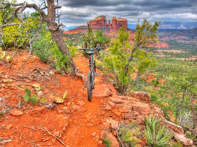
The North Yuba River Trail is without doubt a fantastic trail, and is a must if in the Downieville area. To me it did not impress me as much as the Downieville Classic, but that’s a bit like comparing apples to oranges. The trail is sweet singletrack, scenic and both technically and physically moderate.

Another good thing about this trail, is you could easily do this as an “Out & Back”, filling your Hydro at the Indian Valley Campground.
The downside to this trail can be “Crowds”, I had the trail to myself on a Thursday early morning, but Saturday was mental on the trail.. we are talking probably 100’s of people.


Other Info:

Traffic on Trail: Thursday early morning, and the trail was mine!!.. however weekends the trail is mental! Avoid if possible.

Wild Life : none

Scenery : Great scenery

Getting There : Trailhead in Downieville

Other : If you can, try and avoid weekends, trail gets very busy


My Trail Rating : 8 / 10


Yuba Expeditions Downieville

The North Yuba River Trail was proudly sponsored by :

Yuba Expeditions Downieville

Yuba Expeditions is the one stop bike shop in Downieville, For SALES • SERVICE • DEMOS • SHUTTLES • MAPS • SEMI-ORGANIZED ANARCHY and lots more.

Yuba Expeditions is THE place to get all the up to date trail intel, as well as any parts you or your steed will need while in Downieville.

Yuba Expeditions is also the choice shuttle service of Mountain Bike Mayhem, High on Mountain Biking and Mountain Bike Trails USA.


Yuba Expeditions – Downieville Downhill
208 Main Street, Downieville CA 95936
Tel: (530) 289 3010
www.yubaexpeditions.com


10% discount Mention MOUNTAIN BIKE MAYHEM and receive 10% discount on the Shuttle Service.


Hollenbeck Canyon

Hollenbeck Canyon offers fantastic and scenic trails for some fun mountain biking

.

Hollenbeck Canyon near Jamul, and just 25 minutes east of San Diego offers some fantastic trails through stunning and unique scenery. A seasoned mtb’er can easily put together a fantastic 12-20 miles ( or more) ride, but just exploring all the paths, trails and tracks. From lush green meadows through fantastic shady oak groves to high and open trails with great scenery of the canyon and surroundings

Hollenbeck Canyon Trail Map.


Trail Stats & Information

Nearby Town : Jamul

Length: You decide : the trail I did was just under 10 miles

Trail Type: You decide

Skill Level: [what the books say] no info

Skill Level: [My Opinion] Technically easy. Physically moderate

Duration : My time was 02:07:34

 Elev Gain : 1,265 feet

Top Elev : 1,506 feet

Min. Elev : 761 feet

Book Description

I could not find any Mtb Trail books describing the Highline Trail, because it is not really an “official” trail, so the below descriptions are based on my personal experience :
>> Hollenbeck Canyon offers some really nice trails, both singletrack and doubletrack among scenery that will come as a pleasant surprise. Lush green pastures, shady oak groves and open trails with great panoramic scenery. Their are tons of options for the mountain biker in the canyon, just explore all the trails and tracks for a great day of mountain biking.

.

My Experience

Hollenbeck Canyon came as a complete but pleasant surprise to me. The scenery from the trailhead is quite unique and different from what you might expect. I was lucky that I met 2 fellow mountain bikers at the trailhead, they had just returned from their ride, and I was able to get some very useful info on what trails to take. Even though it was January, it was hot!!, and I can only imagine how unbearable it would be in the summer.

The loop I did was very enjoyable and pretty easy going, even the climb was not too bad, but I did notice that I was drinking more than I normally do, due to the heat. The trails were compact dirt tracks, and pretty fast flowing through fantastic scenery. There are numerous very fast singletrack downhill sections, that require full concentration, because of some gnarly ruts and loose rocks on the trail.


Conclusion
Definitely worth riding, Hollenbeck Canyon offers some fantastic trails with unique scenery. Next time I’m in the area I will definitely spend more time exploring these trails.
.

Other Info:

Traffic on Trail : Although the trail head was fairly busy, I did not see many people on the trails

Wild Life : Snake and plenty of buzzards

Scenery : Great scenery, pretty unique for this area

Getting There : Hollenbeck Canyon Trailhead : the trailhead is just off Campo Rd ( CA94) on Honey Springs Rd

Other : Take lots of fluids, in January it was hot, so just imagine what the summers must be like.


My Trail Rating : 8 / 10

.


.

The Highline Trail in Sedona

  . This is the first ever ride in the USA that I have not done solo.  For this ride I needed a guide, ‘cos there is no way I could have otherwise experienced this trail. Although once on the Highline Trail, it is easy to follow, but finding this trail as an “outsider”  would […]