Tag Archive for: mountain bikers

Flat Pass Trail

Flat Pass Trail aka Steel Bender - Moab Oct. 2011


The Flat Pass trail is a fantastic trail, and chances are that if you can ride this trail on a week day, you will have the trail to yourself. Flat Pass Trail and Steel Bender are not really the same trail, Flat Pass is ideal for mountain bikers, and follows the Steel Bender that is the 4×4 trail, the only difference is, the Steel Bender is about 2 miles longer. For anyone planning a trip to Moab to Mountain Biking should definitely put Flat Pass Trail on the list of “Must do” trails.


Flat Pass Trail Map


  Trail Stats & Information

Nearby Town: Moab Length: Guide book states 15.5 total miles, I myself clocked 19.4 miles from Kens Lake Trailhead and 21.76 miles from Moab Rim Campark

Trail Type: Loop [ out & back is an option ]

Skill Level: [what the books say] Technically difficult to extreme. Physically moderate to difficult.

Skill Level: [My Opinion] Technically moderate to challenging. Physically moderate

Duration: Book say’s 2-4 hours my time 5.56 hours

Trailhead Elev: 5,200 feet

Top Elev: 6,000 feet


Book Description

The ride is highlighted by vandalized petroglyphs, rolling hills with sever transitions at the bottom, and some very beautiful views of the Moab Valley. There are a couple of spots on the trail that can sneak up on you, so keep your eyes on the trail and give blind turns and dips a lot of respect. I you enjoy technical challenge, deep stream crossings, transitions, vertical ridges, gaps and pits, knee-high ledges, rollies, plateaus, babyheads, death-grip-jackhammer stuff into deep sand, weird sliced-bread bedrock, and a ride that can be done form Moab, the Flat Pass is the trail. Trail Surface: Bedrock, loose rock, sand and babyheads on a technical 4WD track, with substantial creek crossings.


My Experience

I had heard a lot of good things about the Flat Pass Trail, and it has been on my to do list for a few years, the only reason I kept postponing this ride was because of the high amount of “Road Miles” needed to loop this trail. The trailhead is easy to find, just head for Kens Lake. The trails starts with a easy climb on a gravel road to the Flat Pass. At this point you head down, and have to make a sharp left and cross the creek, or just do as I did, and miss the turn-off and carry on up a dead end trail untill you realize it ain’t going anywhere, so you will have to turn around and back track. Once on the real trail, which is mostly slickrock, the real enjoyment begins. The trail climbs moderately with plenty of obstacles to keep you busy, and it’s actual a fun climb. The fun continues until you top out, then you get some really fun sections of hard packed sand.. open up here and ride like a bat out of hell, until you hit the rocky downhill section. Technically quite challenging, but nothing too serious, it’s just a fun bumpy downhill, choose your path, and stick to it. There are a few high drop-offs, but I always managed to find a safe way down.. All in all the trail section of the Flat Pass Trail is fantastic, with a high fun factor, and offers stunning Moab scenery. This trail does not attract the crowds like numerous other Moab Trails does.  


Conclusion

This time I started from Moab Rim Campark and looped the whole trail in just under 22 miles. The last time I started at Kens Lake Trailhead, and clocked just under 21 miles. The only downside of the Flat Pass trail is about 50% is on the road. Once you are actually off the road and on the trail, it is absolutely fantastic, and any mountain biker is guaranteed to have a fantastic time. The trail is easy to follow, but you will definitely need a map if you have never done this trail before, as there are a few other nameless trails branching off. There are in total 4 creek crossings on this trail, and my advice is to get your feet wet, and carry your steed across. I did not do this, and after each creek crossing there is a foot of sand and your rear derailleur really gets gunked up. Once on the trail, try and avoid the far sides of the trail, even if it seems the perfect line, try and stay within 2 feet from the sides. I learned the hard way, and had a total of 7 punctures from thorns. For anyone with a bit of extra time and energy, I would suggest riding Flat Pass as an Out and Back, it would shave about 5 miles off the total milage, which means it would be about 16 miles of fantastic pure mountain biking miles.  


Other Info:

Traffic on Trail : none, I had the trail to myself.

Wild Life : none

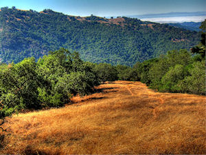
Scenery : Absolutely Fantastic Moab Scenery

Other : Carry a proper map, and like all Moab trails a good puncture outfit and extra inner-tubes, and carry your bike across the creek, the sand will gunk your derailleur.  


My Trail Rating : 8.5 / 10 [ As a P2P I would give this trail a 10/10 ]


Moab Rim CamparkThis Flat Pass Trail review is proudly sponsored by :

Moab Rim Campark

At Moab Rim Campark mountain bikers will definitely feel at home among other mountain bikers at this Mountain Biker Friendly Campgroud.
Bike wash, grassy shaded tent sites with stunning views, Full hook ups, semi hook ups, cabins, group shelters, sheltered areas to tinker on the bikes, and lots more.

The Flat Pass Trail can be looped from your campsite.
Moab Rim Campsite has been recommended by “Mountain Bike Mayhem” 5 years running.

Mountain Bikers get 10% discount, just bring your bike(s) and mention MOUNTAIN BIKE MAYHEM

For more info vist : Moab Rim Campark


Trail Videos taken on the Flat Pass Trail. Oct. 2011  


Henry W Coe State Park Mountain Biking

Henry Who?? … Yep, that was my first response when I knew I was gonna ride in this area.. Now let’s be honest how many people have heard of the Henry W. Coe State Park in California? 
In the Henry W. Coe State Park brochure they call it ” A Mecca for Mountain Bikers”.. Yeah sure I thought to myself, if I had a dollar for every park that said that, I would be rich.
But anyway, I was here for a few weeks and decided for myself if this really was a “Mecca for Mountain Bikers” or just another false alarm..

Henry W. Coe Trail Map


I spent 3 days on these trails, but because you can link and loop however you wish, I’m just going to write about the area in general in one review rather than 3 separate  trail reviews

For a LARGE Map click here


Trail Stats & Information

Nearby Town : Gilroy – Morgan Hill

Length: Your call

Trail Type: Loops

Skill Level: [what the books say] no info

Skill Level: [My Opinion] Technically moderate. Physically demanding –  mental

DAY 1


DAY 2


Day 3


Book Description

Within the over 81,000 acres of Henry W. Coe State Park are about 100 miles of roads and trails that are open to mountain bikes.  The rugged terrain offers a variety of riding options ranging from moderately difficult to extremely difficult.   There are practically no easy trails for bikes.  One intermediate to advanced mountain biker, after a ride in Coe Park, commented, “The riding was the most physically demanding I have ever done!”


Day 1


Day 2


Day 3


My Experience


Day 1 Trails :

Start at : Coyote Creek TH >> head up Coit Rd >>Pick up Ansa Trail on the right >> then onto Jackson Trail >> at the top veer off onto Elderberry Trail >> then make a right and climb Tower Trail >> after a short ride veer onto [Rock] Spring Trail >> onto Jackson Rd >> to Wasno Rd >> take a right onto Dexter Trail >> head down and take a righ onto Grizzly Gulch and take it all the down to Coyote Creek TH where you started.

Day 2 Trails :

Start at : Coyote Creek TH >> head up Coit Rd  for a short while >> veer right onto Grizzly Gulch for a few minutes >> then take a right onto Spike Jones Trail >>bare left on Steer Ridge Rd. >> then take the Serpentine Trail to the end >> left on Grizzly Gulch >> take a right and climb [walk] Tower Trail >> left on Jackson Rd >> continue down Jackson Trail >> left onto Anza >> onto Coit Rd and back to Coyote Creek TH

Day 3 Trails :

Start at : Coyote Creek TH >> head up Coit Rd  for a short while >>veer onto Grizzly Gulch >>then take a left onto Cullen Trail >> trail becomes Anza Trail stay on it >> then head up the Grapevine Trail >> then onto Cattle Duster >> down the Domino Pond Trail >> take a right on Wasno Rd >> sharp left onto Kelly Lake Trail >> down to Kelly lake and then extreme climb [walk] to Wagon Rd. >> right onto Wasno Rd for a short climb >> downhill on the Tule Pond Trail >> right onto Grizzly Gulch and take it all the down to Coyote Creek TH where you started. 


As I mentioned above, I had never heard of Henry W. Coe State Park, now that doesn’t mean much at all, there are 1000’s of places I have never heard of, but I am pretty updated and well informed about [most] Top Mountain Biking Destinations.
I enjoyed every second I spent on these trails, the trails are 95% sweet singletrack, and I mean singletrack!!
The trails are very well marked, but not overdone, the free maps at “Hunting Hollow TH” are excellent, and it would be pretty difficult to get lost on these trails. ( note that there are NO maps at Coyote Creek TH )
All my rides started at Coyote Creek, that offers free parking ( unlike Hunting Hollow that is $6 )
All the trails start by going up, and I don’t care how fit your are, you will spend some time walking with your steed. The views are fantastic, as is the scenery 360 degrees around you.
You would have noticed that some of the trails are roads, but don’t let this fool you, these are not roads, Yes in theory they are “Fire Roads” but even these are a hell of a sweet ride, and better than most trails you find elsewhere.

I enjoyed the climb, even though it was brutal and I spent a lot of time walking, this did not matter, I was already sold by these fantastic network of trails. Once you reach the “Top” you are gonna get blown away by the miles and miles of the sweetest open singletrack you could ever wish for, and the hours you just spent climbing and sweating is all forgotten.

I did these trails in the beginning of September, now I’m not a 100% convinced if this is the best time or not, what I do know, is that it was HOT!!, and I mean hot!. Luckily I like all things hot, but I would love to know when the best time is to ride these trails.. If you are a local, please post a comment and let me know. 

The 3 days I spent on these trails, were fantastic, but I just touched a very small portion of what Henry W. Coe has to offer. I’m glad there is so much more to experience here, ‘cos I will definitely be back to get some more.


Conclusion

YES, I can confirm that Henry W. Coe State Park is a mecca for Mountain Bikers, I will even go as far as to say that it is even in my Top 3 of MTB destinations.
The tails are fantastic, REAL singletrack, the trails are really well marked, the trails are empty, in the 3 days I was on the Trails I saw ONE hiker, and I was even on the trails during Labour Day Weekend. The views and scenery are fantastic, and there are so many fantastic trails here, you can decide on how long a loop you want to ride. 

Your biggest enemy on these trails is the sun and heat, do not under estimate these, I started my rides at the crack of dawn, and by 10 am it was getting pretty unbearable.


Other Info:

Traffic on Trail: EMPTY, 3 days on the trails even during Labor Day Weekend, and I only saw 1 hiker

Wild Life : PLENTY – Bob Cat – Coyote – Wild Boar – Skunk – Deer – Wild Turkey

Scenery : Fantastic views and scernery

Getting There : From Gilroy take Leavesley Rd to New Avenue, then Right onto Roop Road, follow all the way till it becomes Gilroy Hot Springs Road. Pick up map at the Hunting Hollow TH, then continue till the road dead ends at Coyote Creek  TH

Other : It gets HOT here, take extra fluids and nibbles, try and get a very early start. Check yourself for Ticks after the ride, I had a few using me as an “All you can eat”
“Stickers” are a pain here, I actually threw one pair of socks away ‘cos they were covered in them so if possible wear long trousers or a really old pair of socks. 


My Trail Rating : 10 / 10 with a GOLD Star


Hollenbeck Canyon

Hollenbeck Canyon offers fantastic and scenic trails for some fun mountain biking

.

Hollenbeck Canyon near Jamul, and just 25 minutes east of San Diego offers some fantastic trails through stunning and unique scenery. A seasoned mtb’er can easily put together a fantastic 12-20 miles ( or more) ride, but just exploring all the paths, trails and tracks. From lush green meadows through fantastic shady oak groves to high and open trails with great scenery of the canyon and surroundings

Hollenbeck Canyon Trail Map.


Trail Stats & Information

Nearby Town : Jamul

Length: You decide : the trail I did was just under 10 miles

Trail Type: You decide

Skill Level: [what the books say] no info

Skill Level: [My Opinion] Technically easy. Physically moderate

Duration : My time was 02:07:34

 Elev Gain : 1,265 feet

Top Elev : 1,506 feet

Min. Elev : 761 feet

Book Description

I could not find any Mtb Trail books describing the Highline Trail, because it is not really an “official” trail, so the below descriptions are based on my personal experience :
>> Hollenbeck Canyon offers some really nice trails, both singletrack and doubletrack among scenery that will come as a pleasant surprise. Lush green pastures, shady oak groves and open trails with great panoramic scenery. Their are tons of options for the mountain biker in the canyon, just explore all the trails and tracks for a great day of mountain biking.

.

My Experience

Hollenbeck Canyon came as a complete but pleasant surprise to me. The scenery from the trailhead is quite unique and different from what you might expect. I was lucky that I met 2 fellow mountain bikers at the trailhead, they had just returned from their ride, and I was able to get some very useful info on what trails to take. Even though it was January, it was hot!!, and I can only imagine how unbearable it would be in the summer.

The loop I did was very enjoyable and pretty easy going, even the climb was not too bad, but I did notice that I was drinking more than I normally do, due to the heat. The trails were compact dirt tracks, and pretty fast flowing through fantastic scenery. There are numerous very fast singletrack downhill sections, that require full concentration, because of some gnarly ruts and loose rocks on the trail.


Conclusion
Definitely worth riding, Hollenbeck Canyon offers some fantastic trails with unique scenery. Next time I’m in the area I will definitely spend more time exploring these trails.
.

Other Info:

Traffic on Trail : Although the trail head was fairly busy, I did not see many people on the trails

Wild Life : Snake and plenty of buzzards

Scenery : Great scenery, pretty unique for this area

Getting There : Hollenbeck Canyon Trailhead : the trailhead is just off Campo Rd ( CA94) on Honey Springs Rd

Other : Take lots of fluids, in January it was hot, so just imagine what the summers must be like.


My Trail Rating : 8 / 10

.


.