Flat Pass Trail Moab, also known as Steel Bender
.
If there is one thing there is not a shortage of in Moab, it is Mountain Biking Trails. Everyone has a favorite trail here in Moab, but usually you only hear about Slickrock, Porcupine, Sovereign etc. However, the Flat Pass Trail, also known as the Steel Bender, has quite a following of mountain bikers that put this trail on the top of their “Favorites” list.
.

Trail Stats & Information
Nearby Town: Moab
Length: Guide book states 15.5 total miles, I myself clocked 19.4 miles
Trail Type: Loop
Skill Level: [what the books say] Technically difficult to extreme. Physically moderate to difficult.
Skill Level: [My Opinion] Technically moderate. Physically moderate
Duration: Book say’s 2-4 hours [ ?? 2 hours!! ] my time 4.07 hours
Trailhead Elev: 5,200 feet
Top Elev: 6,000 feet
.
Book Description
The ride is highlighted by vandalized petroglyphs, rolling hills with sever transitions at the bottom, and some very beautiful views of the Moab Valley. There are a couple of spots on the trail that can sneak up on you, so keep your eyes on the trail and give blind turns and dips a lot of respect. I you enjoy technical challenge, deep stream crossings, transitions, vertical ridges, gaps and pits, knee-high ledges, rollies, plateaus, babyheads, death-grip-jackhammer stuff into deep sand, weird sliced-bread bedrock, and a ride that can be done form Moab, the Flat Pass is the trail. Trail Surface: Bedrock, loose rock, sand and babyheads on a technical 4WD track, with substantial creek crossings.


.
My Experience
I had heard a lot of good things about the Flat Pass Trail, and it has been on my to do list for a few years, the only reason I kept postponing this ride was because of the high amount of “Road Miles” needed to loop this trail.
The trailhead is easy to find, just head for Kens Lake. The trails starts with a easy climb on a gravel road to the Flat Pass. At this point you head down, and have to make a sharp left and cross the creek, or just do as I did, and miss the turn-off and carry on up a dead end trail untill you realize it ain’t going anywhere, so you will have to turn around and back track.
Once on the real trail, which is mostly slickrock, the real enjoyment begins. The trail climbs moderately with plenty of obstacles to keep you busy, and it’s actual a fun climb. The fun continues until you top out, then you get some really fun sections of hard packed sand.. open up here and ride like a bat out of hell, until you hit the rocky downhill section. Technically quite challenging, but nothing too serious, it’s just a fun bumpy downhill, choose your path, and stick to it. There are a few high drop-offs, but I always managed to find a safe way down..
All in all the trail section of the Flat Pass Trail is fantastic, with a high fun factor, and offers stunning Moab scenery. This trail does not attract the crowds like numerous other Moab Trails does.
Conclusion
The Flat Pass Trail is definitely a “must do” ride if you are in Moab, and I will definitely be doing this one again in the near future. However, I will approach this trail in a different way. Other options for this trail is to ride it as an “Out & Back” which is about the same mileage as a loop. Another loop option is to park your vehicle at the end of the trail, and do the road section first, get it behind you, and end the trail on a high. Or if you are lucky enough to be able to get a shuttle, and ride it as a P2P [ point 2 point ]
One bit of important advice for this trail is if you have never done it before, make sure you take a “proper” trail map, ‘cos there are numerous very confusing spots on this trail where the sign posts are missing and with numerous trails branching off .
Other Info:
Traffic on Trail : none, I had the trail to myself.
Wild Life : A Rattlesnake [ I almost sat on it ]
Scenery : Absolutely Fantastic Moab Scenery
Other : Carry a proper map, and like all Moab trails a good puncture outfit and extra inner-tubes [ Moab trails are notorious for causing punctures]
My Trail Rating : 8.5 / 10 [ As a P2P I would give this trail a 10/10 ]
.
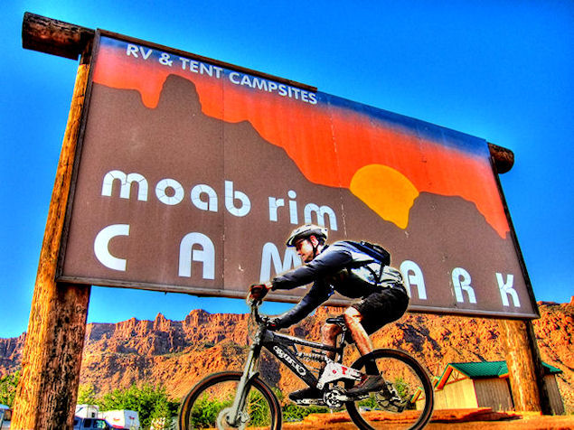
The Flat Pass trail review is proudly sponsored by :
Moab Rim Campark
At Moab Rim Campark mountain bikers will definitely feel at home among other mountain bikers at this Mountain Biker Friendly Campgroud.
Bike wash, grassy shaded tent sites with stunning views, Full hook ups, semi hook ups, cabins, group shelters, sheltered areas to tinker on the bikes, and lots more.Flat Pass Trail can be done directly from your campsite as a loop, there is no need for a shuttle.
Moab Rim Campsite has been recommended by “Mountain Bike Mayhem” 4 years running.Mountain Bikers get 10% discount, just bring your bike(s) and mention MOUNTAIN BIKE MAYHEM
For more info vist : Moab Rim Campark
.
.
.
.